Thank you to everyone who was able to participate in our 1pm
conference call - and for our faith partners of Operation Brother's Keeper who were able to attend in person! There has been much collaboration
and discussion today beginning with an internal meeting with Norfolk City and
Norfolk Public Schools, followed by a conference call with VDEM and NWS, and
then our Team Norfolk call. Bottom line:
we continue to plan for the worst-case scenario and hope for the best. The storm track made such a substantial
change in a short period of time and nothing says it won’t happen again. If it does, Team Norfolk will be ready.
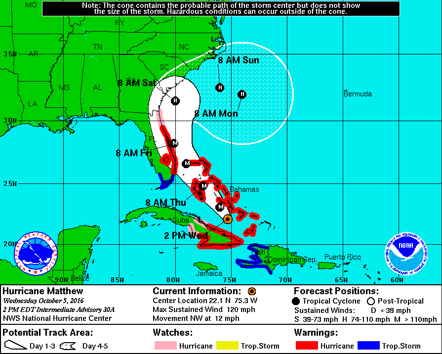
Current forecast is attached for your review. You’ll see the storm track has moved further
south and west away from Virginia. As
such, those major impacts previously forecasted have significantly diminished. Scattered showers are expected at the end of
the week with a greater chance (74%) Saturday morning around 8am. Total rain forecasted is less than one inch. Wind gusts in the mid to upper 30’s should
occur late Saturday night / Sunday morning, weakening throughout the day. Again, while not a threat by itself, with the
degree of ground saturation caused by 10-15” of rain over the past few weeks,
downed trees and sporadic power outages can be expected.
Per the tide chart below, tidal / nuisance flooding will
also occur. The forecast goes through
Saturday and shows the high tides for tonight/Thurs morning at 12:42am and
Thursday at 1:09pm approach the minor flood stage which will result in nuisance
flooding in the typical areas. To see
how this may look around your points of interest, go to our TITAN program at http://gisapp1.norfolk.gov/TITAN/HOME.aspx
and for the Flood Layer enter one foot LESS than what is forecasted on the
chart (this takes into account the conversion from MLLW to NAVD88 resulting in
a more accurate picture). In other
words, with a forecast of 4.5’ on the tide chart, go with 3.5’ in TITAN.
We have discussed storm preparations currently underway as
well as the availability of shelters, parking safe havens and more. So much depends on forecast developments and we
expect to have Friday the information necessary to act on our plans or stand them down. In the meantime, however, it is critical to
maintain communications with our community.
Thanks to all who have been pushing Norfolk Alert! Please continue to do so!! We also need folks to use this event as a reminder
to review their preparedness kit and their plan, to get to know their neighbors
(on whom they may rely or assist during a disaster), know how to stay connected
with information and how they may get plugged in with response / recovery
efforts. Many of this information is
available at http://www.Norfolk.gov/Emergency.
Should the storm track continue to move away from us,
updates will become less frequent.
Nonetheless, they will continue until the threat is gone. Thank you to all for your partnership,
contributions and all you do to make Team Norfolk the effective force it is for
our community!
Sincerely,
Jim


No comments:
Post a Comment