Team Norfolk:
Provided below is a brief from Bill Sammler, Warning Coordination Meteorologist with the National Weather Service in Wakefield. Hourly forecast graph information attached for your review. Bottom line: very cold temperatures tonight through Saturday morning; precipitation does not appear to be a threat for our area.
Messaging should include dressing appropriately (infographic below), taking steps now to prevent frozen pipes, keep your pet indoors and check on those who may be a little more vulnerable to the conditions.
Thanks and be safe!
Jim
Director, Norfolk EOC
james.redick@norfolk.gov
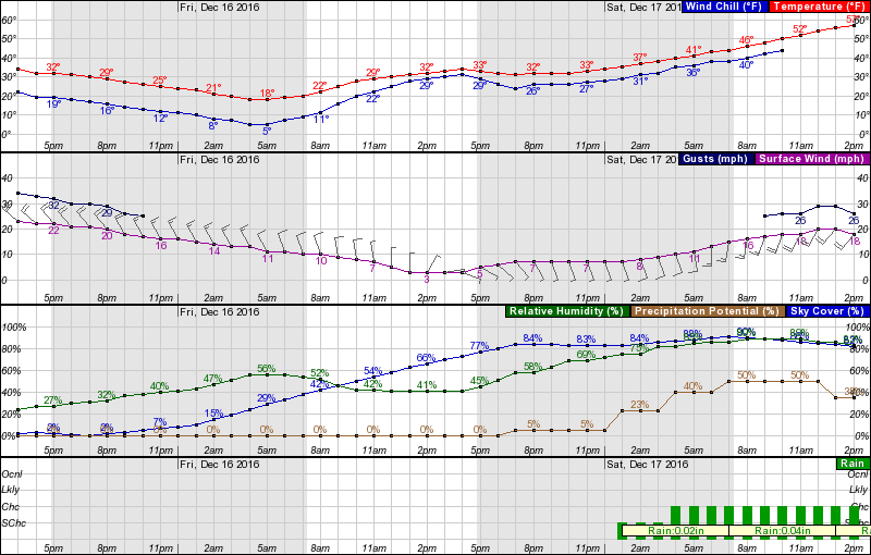
“The coldest airmass this winter continues moving into the region this afternoon. Temperatures will fall quickly through this evening, with most areas being in the 20-25 degree range by 9 pm. Winds will continue to be strong and gusty this evening, especially near the Bay, Ocean and Sound, making it feel 10-15 degrees colder than the actual air temperature. A very cold night is in store across the region tonight, with low temperatures below 20 degrees throughout our region. Most locations on the Lower MD Eastern Shore, and inland from the Bay/Sound in VA/NE NC in the 10-15 range. Wind chills around or just below zero on the DELMARVA and Northern Neck, and in the single digits elsewhere, will make Friday morning bitterly cold. A wind chill advisory, for wind chills zero to -5 degrees is being issued for our DELMARVA and Northern Neck counties, except for Northampton county VA. Friday's max temps will struggle to reach 32 degrees everywhere. Wind chills will not be much of a factor by mid-morning Friday, except across our DELMARVA area, and coastal Hampton Roads/NE NC, where winds continue to be gusty, but deceasing, through noon.
Potential for Wintry Precipitation (mainly interior VA)
There is little change to our thinking from yesterday regarding the potential for light freezing rain late Friday night through mid-morning Saturday. Low pressure organizing in the southern Plains Friday evening will intensify as it moves toward the Great Lakes region on Saturday. As warmer air surges toward the region from the southwest, a light wintry mix of snow, sleet and freezing rain will be possible Friday night into Saturday morning, especially west of Interstate 95, and north of a Richmond VA to Ocean City, MD line. The most likely areas for light accumulations of ice will be along and west of a Vienna MD to Tappahannock VA to Richmond VA to Emporia VA line. The emphasis here is light accumulations (generally less than one-tenth of an inch). However, since temperatures will have been so cold for 36 hours or so prior to the onset of precipitation, any freezing rain could cause rapid development of hazardous traveling conditions in the area mentioned above during the period from midnight Friday night through mid to late morning Saturday. The last areas for precipitation to turn to rain will be Fluvanna and Louisa counties. Even in these areas, only light ice accumulations area expected. All precipitation with the weekend event beyond noon Saturday will be liquid rain, with temperatures well above 32 degrees.
Additional info will be provided tomorrow afternoon. However no briefing packages are anticipated, due to the light and short-lived nature of the event. The front page of our briefing web page will have the latest storm total snow/ice graphics on the right side of the page. An afternoon update to these graphics will be available by 5 pm.”