Wednesday, September 6, 2017

Team Norfolk - Hurricane Irma Update - 9-6-27 @ 6:30pm

Team -


No doubt you 
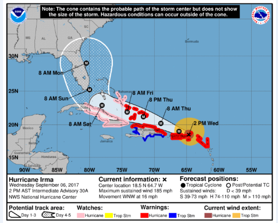
have been following the track of Hurricane Irma (click on link and see VDEM storm dashboard below), and no doubt you’ve also noticed the recent changes in its track.  Internally, our conversations and response efforts began over the holiday weekend with “what if?” scenarios – planning for the worse and hoping for the best.  Based on the latest tracks, these discussions have not been for naught. 
We have reached out to several partners already and today initiated 24-hour operational periods with daily situation reports and Emergency Operations Center briefings.  In other words, based on our plans and checklists, we are focusing on those immediate tasks based on our hurricane readiness level from 4:00pm today through 4:00pm tomorrow while our Planning section is always looking ahead modifying or establishing goals and objectives for the following 24-hour operating period.  This is the Incident Command System.

A proactive unity of effort is what we strive for throughout Team Norfolk Emergency Operations.  As such, you are part of this process.  Therefore, starting tomorrow (9-7-17), please send your storm response status as well as your intentions / needs for the next 24-hour period no later than 2pm to EOC-Plans@norfolk.gov.  (If you know your long-term resource needs feel free to share them as well).  Our daily Team Norfolk EOC Briefing call will commence at 3pm followed by an internal conversation among our Policy Cell at 4pm.  Please be advised: the EOC Briefing call will in fact be brief.  An update on the threat will be provided as well as a status on the unified goals and objectives.  Resource needs should have already been submitted through the situation reports and thus will be included in the briefing, but only as confirmation.  These calls are to ensure shared situational awareness while not delaying preparedness efforts.
If you do not receive an invitation to participate on the EOC Briefings, please do not be offended.  It is merely due to the fact there are only so many ports available.  All that is provided and discussed will be shared without delay!

More to follow tomorrow, including the latest copy of our Basic Plan and Hurricane Annex as well as the accompanied Battle Rhythm (checklist of action items for each hurricane readiness level).  Please read it and challenge it so it can be improved!  Also, in order to ensure a comprehensive community response to the storm(s), please remember to submit a situation report no later than 2pm every day until the storm dictates otherwise (sitreps become more frequent or the storm blows away).
Ladies and Gentlemen – this is what we do.  We have our plans in place and we have each other = TEAM NORFOLK.  Please take this time to prepare personally and for your family.  Hurricane Irma could prove to be the real deal and we’ll need all hands-on deck to respond and recover.

Please feel free to contact me with any questions or concerns.
Thank you!!

Jim
Jim Redick, Director
Norfolk EOC
james.redick@norfolk.gov


Team Norfolk - Hurricane Irma - 9-6-17 @ 3pm

Ladies and Gentlemen,

Please see the following update from Jeff Orrock, Meteorologist in Charge for the National Weather Service in Wakefield:
“I know everyone has been watching the forecast track of Hurricane Irma intently. We are still in the long-range stage of predictions with this system and forecasts will change, however, given trends in the guidance over the past few days turning the storm north our concern is increasing (see attached images of NHC forecast track and guidance uncertainty). There is good agreement that Irma will make a turn to the north at some point, the main questions are; when and how far does Irma track west before turning? The answers to these questions will eventually determine impacts on our region and the timing of those impacts. 

At this stage given all the guidance, it is becoming more likely that we will see some degree of impacts in regards to wind, heavy rain/flooding and tidal flooding. The extent and timing of each of these possible impacts depend on the track of the storm. The EARLIEST timing for increasing winds would be some time Monday into Tuesday. 
Summary:
  • Hurricane Irma becoming more of a concern for early next week.
  • Hurricane Irma could be a major hurricane posing a threat to the Carolinas Monday into Tuesday. 
  • Mid-Atlantic region will like experience various impacts from Irma
  • Exact track, impacts and timing of those impacts remains uncertain
  • Forecasts issued Thursday will likely place at least southern VA and NC within the 5-day forecast error cone and on the edge of Tropical Storm Force Wind probabilities. 
We will send out an update again tomorrow to help set the tone regarding any changes in the forecast.” 

----------
Thanks, Jeff, and thanks everyone!

Jim
Jim Redick, Director
Norfolk EOC


Tuesday, August 29, 2017

Team Norfolk Weather Update 8-29-17 @ 9:30am

Ladies and Gentlemen,

The latest update from Mike Dutter at the Nation Weather Service is as follows:

“Good Morning,
Attached is our latest weather briefing for the ongoing coastal low. Not a great deal has changed since our previous briefing...
  • We are still expecting wind gusts of 45 to 55 mph this afternoon closer to a coast and over the water. A High Wind Warning for coastal locations and Storm Warning for most marine areas are in effect.
  • Localized flooding is possible from heavy rainfall today, especially along the coastal plain. Although, even the I-95 corridor may have a small threat for minor flooding.
  • Since the storm is moving quickly, the threat for coastal flooding will be confined to the high tide cycle this afternoon with water levels 2-2.5 ft above normal. We are forecasting minor coastal flooding for points in Hampton Roads. Jamestown, Yorktown and Kiptopeke may approach moderate coastal flooding.
  • Dangerous surf and rip currents today.
Thank you, and please do not hesitate to contact us with any questions. You can also find this briefing at http://www.weather.gov/media/akq/briefings/LatestBriefing.pdf

-----------
For our area specifically, the hourly graph suggests we can expect another 2” of rain between now and 7pm.  Furthermore, wind speeds should now begin to increase with gusts nearing 50mph between 3-8pm.  The tide forecast has fallen back below the moderate flood stage; however, some flooding at the usual spots is expected. 

We'll continue to monitor and provide updates as appropriate.

Thanks!
Jim

Jim Redick
Director, Norfolk EOC
james.redick@norfolk.gov


Monday, August 28, 2017

Team Norfolk Storm Update 8-28-17 @ 3:30pm

All,

The Emergency Operations Center participated in the afternoon conference call with the Virginia Department of Emergency Management (VDEM) and the National Weather Service in Wakefield.  Bill Sammler reported the following [paraphrased] on behalf of the NWS:
The tropical system, expected to become Tropical Depression or Tropical Storm Irma, is still a bit disorganized but expected nonetheless to make its way up to Coastal Carolina and then move quickly off shore.  It’s during this time the storm is expected to intensify. 

Rain is expected between now and midnight Tuesday night with overall accumulation of ~2-4”.  The period of greatest impact regarding winds and storm surge are tomorrow (Tuesday) 10am to midnight.  Winds will be the strongest during that same timeframe with gusts expected in the 50-60mph range.  The forecast for minor to low-end moderate flooding on the tides chart is not expected to change.


The storm-specific link remains http://www.weather.gov/akq/PTC10 until the name is changed to Tropical Depression and/or Tropical Storm Irma.
The Hourly Graph attached reflects wind gusts peaking at 51mph Tuesday at 5pm.  Moreover, the rain combined with a 3:55pm high tide will result in nuisance flooding and certainly in the low-lying coastal areas.  72-Hour Precipitation Forecast and Tide Chart reflecting ~1.5" for Norfolk also attached.

More to come.

Thanks!

Jim
Jim Redick
Director, Norfolk EOC
james.redick@norfolk.gov


Team Norfolk - Storm System Update - 8-28-17 @ 11am

Team,

Here is the latest from Mike Dutter of the NWS in Wakefield:
"Attached is the significant weather briefing for the expected coastal low, affecting the area Tuesday.  In summary:
  • At this time we are expecting strong NE winds of 30 to 35 mph with gusts to 50+ mph across coastal VA, including areas near the Bay, NE NC and the lower MD eastern shore. A high wind watch is in effect for many of those areas. 
  • Heavy rainfall of 3 to 5 inches could cause some flooding across NE NC and SE VA.
  • Moderate coastal flooding is possible during Tuesday's high tide cycle, especially across Hampton Roads
  • Marine conditions in the coastal waters and lower bay will become dangerous. Wind gusts of 45 to 50 knots and waves of 8-12 ft can be expected across the coastal waters, with similar conditions across the lower bay.
  • High surf and dangerous rip currents will persist along the shore through Tuesday.”
-------

Mike included several graphics in his briefing; I will simply add the latest hourly graph and tidal forecast.  The hourly graph shows 1 ½ “of precipitation beginning this evening through the early morning hours of Wednesday as well as peak wind gusts of ~50mph Tuesday afternoon.  Tide chart continues to show high tide of significance is Tuesday around 4pm.  To get a sense of what the 5.6’ tide may look like, you can visit Norfolk’s TITAN program and enter a Flood Layer (NAVD88) of 4.0 or 4.5 ft.
Norfolk is under a High Wind Watch and a Flash Flood Watch until tomorrow (Tuesday) at 8pm with the additional Hazardous Weather Outlook.

The storm track will be updated by the National Hurricane Center at 11am, the Virginia Department of Emergency Management scheduled a conference call for 3pm this afternoon and the next NWS Wakefield Brief will be 5pm. 
Stay tuned… We’ll keep you posted.

Jim
Jim Redick
Director, Norfolk EOC
james.redick@norfolk.gov


Sunday, August 27, 2017

TEAM NORFOLK - 8-27-17 - Potential Impacts from Tropical System Monday through Tuesday


Ladies and Gentlemen,


Please see the following from Bill Sammler, Warning Coordination Meteorologist with the National Weather Service in Wakefield:


“At 5 pm, the National Hurricane Center will be initiating advisories on an area of low pressure east of the Georgia coast that could become tropical storm Irma by tomorrow. As a result, a Tropical Storm Watch has been issued along the North Carolina coast as far north as Currituck Beach Light. This system's greatest impacts will be in southeast Virginia and coastal northeast North Carolina, although rain and gusty winds could extend well inland, and potential coastal flooding could impact our entire coastal/Chesapeake Bay area. Below are some potential impacts and timing.


Coastal Flooding - Minor flooding possible entire area, with moderate flooding possible in the lower Chesapeake Bay and tidal portions of the James River (at least as far upstream as Jamestown). Expect coastal flooding to begin later Monday and continue into Tuesday. Detailed forecasts are available on our Tides and Coastal flooding page.

Rainfall - Most areas will receive one half inch of rain or less during the event. The exception will be along and east of a Chincoteague to Roanoke Rapids line, where 1 to 2 inches of rain will be possible. Some areas near the coast could receive 2 to 4 inches of rain, within slightly higher localized amounts possible. See our Rain and Snow Forecasts page for details.

Winds - Edenton to Chincoteague eastward - Wind gusts Monday night through Tuesday could get in the 40 to 45 mph range, depending upon how much the area of low pressure intensifies. Elsewhere, wind gusts will be in the 20-30 mph range, highest near the Bay, and Lower Maryland Eastern Shore.

There remains a fair amount of uncertainty with regard to the intensity of this system, and whether the center remains over water as it lifts along the coast. We hope to have more details to provide you by tomorrow morning. If so, a detailed briefing may be issued.”

---------------

I’ve attached the Tropical Storm graphic which reflects the TS Watch Bill mentioned, the hourly graph, 3-day rainfall forecast and tidal forecast for your review.  Again, currently, timing for such impacts begins tomorrow (Monday).  Minor flooding expected with Monday’s 2:55pm high tide (a couple hours before and after), nuisance flooding during the early morning (3:10am) high tide Tuesday and then moderate flooding associated with Tuesday afternoon’s high tide which peaks at 3:49pm. 

All subject to change; we’ll continue to monitor and keep you posted.  In the meantime, feel free to contact us with any questions.

Thanks!

Jim

Jim Redick
Director, Norfolk EOC
james.redick@norfolk.gov


Friday, July 28, 2017

Team Norfolk Inclement Weather 7-28-17

Team Norfolk,

Please see the following as provided by the National Weather Service in Wakefield:

"Low pressure slowly tracking across the Mid-Atlantic region will result in periods of moderate to heavy rainfall this afternoon through Saturday morning. Low pressure slides offshore Saturday afternoon, with lingering showers expected generally east of Interstate 95 through Saturday night. A flash flood watch has been issued for this afternoon through Saturday morning for areas north and east of Richmond. Total rainfall amounts of 2 to 4 inches are expected on average across the watch area, with locally higher amounts possible. For more information, please refer to the attached slides or our Rainfall Briefing Page (link: www.weather.gov/akq/rainandsnow).

In addition, the slight risk for severe weather has been downgraded to a marginal risk for the entire Wakefield forecast area. A few late afternoon and evening thunderstorms may become strong to severe, with locally damaging winds and frequent lightning the main threats. To keep up with the latest severe weather outlooks, check out our Severe Weather Briefing Page (link: www.weather.gov/akq/SevereThunderstorms). 

Low pressure slides offshore Saturday, with increasing north to northeast winds late Saturday through Sunday. Gusts of 25-30 mph are expected along the coast. North to northeast flow will also result in above normal tidal departures. Minor flooding is possible along the coast and in the lower Chesapeake Bay."

-----

 As it pertains more specifically to Norfolk, rain is very much likely today and throughout the weekend; however, our area is not in the flash flood watch nor are the rain amounts during the projected times such to overwhelm our storm water infrastructure.  Incidentally, per the attached Tides chart, the tides begin to stack tomorrow (Saturday) resulting in a chance for tidal flooding during the Sunday afternoon high tide (3:41pm) which combined with the rainfall will result in flooding in the usual areas.  Remember, to tides take a little while to come in and recede, so flooding is expected leading up to the high tide and sometime thereafter.  For a graphic of what the tidal inundation might look like given the current forecast (but not including the impact of rainfall), visit  Norfolk’s TITAN program at http://gisapp1.norfolk.gov/TITAN (for the appropriate conversion, use 1-1.5’ less in the flood layer than what is displayed in the tide chart.  With a forecast of 4.5, select 3.5 or 3’ in the TITAN flood layer). 

As with all things weather, it is subject to change.  We’ll certainly continue to monitor and update you of any changes.
Thanks!
Jim
Director, Norfolk EOC


Wednesday, July 12, 2017

Team Norfolk - HEAT ADVISORY - 7-12-17

Ladies and Gentlemen,

The following is a summary of today’s heat advisory and Team Norfolk’s response efforts.  Thanks to all for your prompt responses and assistance!!  If there are any questions, or other activities for which I am unaware, please email me at your earliest convenience.
Thank you!

Jim
Director, Norfolk EOC

Hazardous Weather Outlook: Hot and humid conditions are expected Wednesday and Thursday. Heat index values around 105 degrees are expected each afternoon. Per the attached chart, heat index values this high will pose a risk of heat related illnesses, if precautions are not taken. Heat advisories may be needed for portions of the area, especially Thursday.
Status: Norfolk Public Libraries are available for a reprieve from the heat during normal operating hours.  Mike Wasserberg reports Office to End Homelessness activated their water outreach for this week. Street outreach has hit most of the known hotspots including parks, libraries and the beach areas. Staff reports low numbers of people experiencing homelessness in the outdoor areas where they would be exposed to the high temps.  Also coordinating with NCSB PATH and Road to Home outreach staff.  Mike also reports the Salvation Army opened its 19th Street Hope Center as a community cooling location until 4pm.

Many, many thanks to Ms. Joleen Jones, Manager at Walmart on Military Highway, as well as Mr. Anthony Butts of Lowes on Military Highway, for their incredibly generous donations of  bottled water for the outreach efforts to our most vulnerable populations!!  Arrangements underway for the pickup and distribution of said water.  Thanks also to Jody and Operation Blessing who are standing by to provide more upon request!
Messaging / Information Resources:
These are the message points approved by Norfolk Public Health.  Thanks, Dwayne and Eve!! 


  1. Dress appropriately for the heat. Wear light-colored, loose fitting clothing that permits the evaporation of perspiration.
  2. Prepare for, and be aware of signs of, heat stress / heat illness.
  3. Protect pets by bringing them indoors.
  4. Do NOT leave children or pets in an un-air-conditioned vehicle.
  5. Anyone without access to air-conditioning can seek temporary relief during business hours at city multi-service centers or libraries.  Contact the Norfolk Cares Call Center at (757) 664-6510 to ask for the nearest open city facility.
  6. Increase water consumption!!
  7. Conduct outdoor work or exercise in the early morning or evening when it is cooler. Outdoor workers should drink plenty of water and electrolyte-replacement beverages and take frequent breaks in the shade or in an air-conditioned facility. Those unaccustomed to working or exercising in a hot environment need to start slowly and gradually increase heat exposure over several weeks.
  8. Check on our seniors. Take the initiative to visit seniors to look for signs of heat related illnesses. It takes the elderly nearly twice the time of younger people to return to core body temperature after exposure to extreme temperatures.
We also received the following from Dominion Energy regarding energy summer saving tips:

  • Raise your thermostat to 78º. If you are away from home for more than eight hours, raise the thermostat setting and you can save for each degree of setback. This will reduce the amount of energy used to cool your home while you're away. You can learn more about your thermostat online by visiting the U.S. Department of Energy website.
  • Keep shades closed when the air conditioner is on. Sunny windows can add heat to your home and can make your air conditioner work two to three times harder.
  • Check and clean filters. Cleaning and replacing air conditioning filters monthly allows the system to run more efficiently.
  • Clear attic vents.  If the home has an attic fan, make sure it is functioning properly.
  • Install ceiling fans and make sure they are blowing down. Don't underestimate the importance of ceiling fans. Moving air over the body provides a cooling effect. Most fans have a switch to change the fan direction. Make sure ceiling fans are blowing downward (in a counter-clockwise direction) to send air past your body. Turn fans off when the room is unoccupied.
  • Postpone activities that require hot water and large energy use – such as washing dishes or clothes – to early morning or late evening.  This will keep from adding more heat and humidity to the home.  Use the dishwasher and clothes washer late in the evening. When used during the day, these appliances produce additional heat, causing your air conditioner to work harder.
  • Use cold water to wash dishes and clothes. This will save on water heating costs.
  • Unplug equipment not in use. Electric chargers, televisions and audio/video equipment use electricity and produce heat even when they are not in use. Running an older refrigerator can use up to three times the energy of a modern one. Unplug any appliance when it's not in use.
Heat Index chart and Infographics attached:


Monday, May 22, 2017

Team Norfolk - Impending Wet Weather 5-22-17 @ 2pm

Ladies and Gentlemen, the following comes from our friends at the National Weather Service in Wakefield.  The graphic they provided is attached.

-----------
“We are anticipating an extended period of wet weather starting today and continuing through at least Wednesday night. Low pressure organizing over Texas this morning will rapidly move northeast tonight, then cross the local area on Tuesday. Moderate to occasionally heavy rain will accompany this low as it moves through on Tuesday, starting first across the Piedmont during the pre-dawn hours, then spreading east to the Eastern Shore by afternoon. There will be a reprieve from the wet weather Tuesday night through at least midday Wednesday before another round of showers and thunderstorms impacts the area late Wednesday afternoon into Wednesday night.
Rainfall totals through Wednesday night will range from 1-3" with locally higher amounts possible. Again, most of this rain occurs during the day on Tuesday.

Ponding of water on roadways as well as minor flooding of creeks, streams and other low-lying or poor drainage areas is expected. However, a lack of rainfall over the past week will preclude a widespread flooding threat. Rises on area rivers will occur as well.”
-----------
The hourly graphs are also provided below validating the aforementioned forecast comments.  80% chance of rain throughout the evening equaling 1/2” between 3-8pm.  Another bout of rain expected tomorrow (Tuesday) between 8am-7pm with around 1 ¼”.  Rain possible throughout Wednesday and Thursday, but at this point, to no degree of concern.  High tide Wednesday evening is at 4.1’ (see tidal chart below), however, which will likely cause the usual flooding in the coastal areas.   Using the City’s TITAN program (open in Google Chrome), enter 3’ for the Flood Layer (NAVD88) for a glance of the location and amount of flooding expected.

Thanks and be safe!

Jim
Director, Norfolk EOC
james.redick@norfolk.gov


Monday, May 15, 2017

Hurricane Exercise 5-15-17

Due to the lack of interest / reviews over the past week, the Norfolk EOC will reallocate the time posting exercise response information to other planning initiatives.  Please feel free to contact me if you have any questions.

Thank you,

Jim
Director, Norfolk EOC
james.redick@norfolk.gov

Friday, May 12, 2017

HURRICANE EXERCISE 5-12-17 @ 3:30PM

THIS IS AN EXERCISE… EXERCISE… EXERCISE…

Here is the latest on Hurricane Brady from Fleet Weather Center and Naval Station Norfolk’s Emergency Manager, Gene Lambert:
Hurricane Brady is currently a strong CAT 3 hurricane located approximately 110 miles North/Northwest of Miami, FL [see attached graphic]. BRADY is forecast to continue to track parallel to the FL coastline and decrease slightly with land interaction. Once near the GA coast, BRADY is forecast to make a turn to the NE and pick up speed, making landfall near CAPE Fear, NC as a CAT 2 hurricane. It will then track NE just inland up the NC coast before exiting back over water near the NC/VA border making CPA [closest point of approach] to NAVSTA Norfolk Tuesday morning around 8am. We remain on the left side of the track which has the lower winds and as such, the Destructive Winds forecast is showing maximum winds on station of [69mph], with onset of [39mph / tropical storm force] winds beginning around 3am Tuesday morning.  Onset of [57mph] winds will begin at 8am Tuesday morning. Current forecast is showing a storm surge of 5-7ft.

The period after storm passage is expected to bring the highest storm tides for Norfolk as winds shift out of the NE. Based on a storm surge of 5-7 ft, we could see a storm tide of 8-10 ft based on storm passage and timing of hi/lo tides.  [Again, this is more than what was experienced during Hurricane Isabel and the 1933 Hurricane.]

--------

With weekend pause in exercise play, we pick back up Monday so for this update we’re considering ourselves approximately 72-48 hours before landfall.  The Norfolk EOC is in Readiness Condition 3 at 72 hours before landfall, and Condition 2 at T-48.

Remember, at this point we’re already at a partial Emergency Operations Center (EOC) and Joint Information Center (JIC) activation with a local emergency declared.  There is a steady stream of communication and information sharing among Team Norfolk Emergency Operations, our partners throughout the region and the State, and most certainly throughout our community.  Volunteer organizations alerted and on stand-by.  State resources have been requested.  Communications are in place.  Shelters are ready.  Venues / special events identified and ready for closure.  Parking safe havens in municipal garages, school parking lots and other venues have been identified.  Efforts have been made with a strategy in place to ensure communication with, and sustenance for, our residents who may be vulnerable due to access and functional needs or poverty / hunger.  (See previous update). 

In advance of actual landfall, Economic Development has identified potential sites which may be used for post-storm recovery centers (where, if FEMA Individual Assistance is made available folks could go and receive help from FEMA, the Small Business Administration and Voluntary Organizations Active in Disaster) and if needed a Joint Field Office (a coordination site among local, regional, state and Federal stakeholders).

Messages to the community:

  • Folks can view potential flooding scenarios using Norfolk TITAN.  Sample graphic provided below.  NOTE 1: for the appropriate conversion, use 1-1.5’ less in the flood layer than what is displayed in the tide chart.  With a forecast of 10’, select 9’ or 8.5’ in the TITAN flood layer.  Note 2: this shows flooding from inundation only; additional flooding from rainfall or wave activity are not reflected.
  • Make sure you have the necessary supplies for whether you stay in place or evacuate.  More information available at http://www.norfolk.gov/index.aspx?NID=658.
  • Be prepared to evacuate if ordered!  You will be notified via Norfolk Alert (you must subscribe) and other means such as Norfolk.gov, social media and TV48.  Information will also include which shelters are to be opened and at what time.  Know what to expect in a city shelter! (website and video).
  • Be sure to inventory and document important paperwork and valuables!  Review your insurance to find out what you might need on hand to file a claim.  Remember – flood damage is not included in a homeowner policy and it takes 30 days for a flood insurance policy to go into effect! 
  • While taking steps to protect your home, make sure they’re effective!  Taping windows is not effective!  If resources permit, information on how to board up windows with plywood can be found here.  
NOTE: AT THIS POINT THE EXERCISE IS PAUSED FOR THE WEEKEND AND WILL RESUME NEXT WEEK.  THANKS FOR FOLLOWING ALONG AND BE SURE TO CONTACT US WITH ANY QUESTIONS YOU MAY HAVE!

Thank you and have a great weekend!

Sincerely,

Jim
Director, Norfolk EOC
james.redick@norfolk.gov


THIS IS AN EXERCISE… EXERCISE… EXERCISE…

Thursday, May 11, 2017

HURRICANE EXERCISE 5-11-17 @1:30PM

THIS IS AN EXERCISE… EXERCISE… EXERCISE…

Morning update reports Hurricane Brady – a Category 3 storm – is located approximately 225NM southeast of Miami (see attached graphic), tracking northwest at ~11mph.   Maximum sustained winds are 126mph and gusts of 143mph.  According to the Saffir-Simpson Hurricane Wind Scale, a storm of this magnitude has the ability to cause devastating damage: “Well-built framed homes may incur major damage or removal of roof decking and gable ends. Many trees will be snapped or uprooted, blocking numerous roads. Electricity and water will be unavailable for several days to weeks after the storm passes.”  Current track forecast has Brady reaching our area Sunday morning (T-72 hours).  Extended forecast suggests some weakening of the storm, but not as much as we would hope.
At the 96-hour mark, the Team Norfolk EOC moves into Readiness Condition 3 (which simply states the forecasted arrival of tropical storm force winds are expected within 96-48 hours) with a partial activation.  Also by this point a pre-landfall local emergency would have been declared (and likely a Governor declaration as well). As mentioned previously, this declaration serves as a trigger by which we can request state and federal assets.  If a CAT-3 or CAT-2 is expected, there would be a number of pre-scripted requests submitted to the Virginia EOC.  Also, with regular monitoring of the surge models, wind timing and rainfall forecasts, discussions would be well underway regarding evacuations. 

While evacuations would not be called for at this time, communication throughout the community explaining the process would be.  One video which would be shared through Norfolk.gov, social media and TV48 would be Mermaid City: Unpacked – Hurricane Evacuation.  We would also be reminding folks of the ways by which they could receive official storm-related information via the episode, “Information Sources During a Disaster.”  
Discussions would also be underway between the EOC, Public Health and our hospitals and healthcare facilities (including assisted care / long-term care, dialysis, etc.).  Furthermore, we would reach out to our partner, Endependence Center, who serves as our Access and Functional Needs liaison in the EOC, as well as our Operation Brother’s Keeper faith community partners to reach out to individuals with various access and functional needs and further warn them of the impending storm.  One video we often share was developed by the Virginia Healthcare Emergency Management Program entitled “Dare to Prepare.” 

Shelters, shelter teams to include communications (amateur radio) and transportation support are already on stand-by; however, additional logistics would be considered by now to ensure appropriate level of care.  Norfolk possesses a Shelter Support Unit (SSU) consisting of various medical capabilities.  While this equipment is inventoried and checked on a regular basis, we would partner with Norfolk Medical Reserve Corps and possibly the Metropolitan Medical Response Team to do so again.  More than ensuring the availability and functionality of the SSU resources, procurement process would be underway to secure professional contract nursing staff.  All shelters will be ADA-compliant and rather than having one shelter with all the SSU equipment, various equipment should be available to each shelter depending on request and severity of need.  Another message for the community would be “What to Expect in an Emergency Shelter.”
Stay tuned - more to come with the next update!

Thanks!
Jim
Director, Norfolk EOC
james.redick@norfolk.gov


THIS IS AN EXERCISE… EXERCISE… EXERCISE…

Wednesday, May 10, 2017

HURRICANE EXERCISE 5-10-17 @ 9:30AM

THIS IS AN EXERCISE…EXERCISE…EXERCISE…

Team,


The latest information from the Navy Fleet Weather Center in Norfolk has Hurricane Brady Southeast of Miami and moving along its projected path at 10mph.  Sustained winds are 120mph (and gusts of 138mph) which makes Brady a Category 3 storm.  Expected arrival of tropical-storm force winds is still approximately 4-5 days (96-120 hours).
Forecast confidence is typically not strong outside of 36 hours before landfall and Team Norfolk would still be at Readiness Condition 4; however, a CAT-3 at 120 hours out, the EOC would request the City Manager declare a local emergency.  This pre-landfall declaration, which coincides with the Governor’s timeline for a State declaration, is more of an administrative trigger to begin capturing all incident-related preparation and protection costs.  A local declaration is also a requirement before we begin requesting resources from the state.  For instance, we may very well request from the Virginia EOC in Richmond high water vehicles and water rescue teams from the Virginia Army National Guard.

The Planning Cell in the Norfolk Emergency Operations Center continues monitoring NHC products such as their Public Advisories, Forecast Discussions, Wind Speed Probabilities, Track Forecast and Cone and Probabilistic wind timing.  We would also continue having conference calls based on the latest updates with the National Weather Service and the Virginia Department of Emergency Management.  Again, we would be conducting EOC briefings with all of Team Norfolk, which is inclusive of public, private, nonprofit, public/higher education, military and our faith community, and providing spot reports via email.  All organizations plugged into Team Norfolk are all getting the same critical information.  If you are not already part of Team Norfolk Emergency Operations but would like to be, ask us how you can!!!

The EOC and Joint Information Center (JIC) would be prepped for a full activation.  Shelters and shelter staff, to include our partners with Norfolk Public Schools (i.e. bus drivers, custodial, facility leadership) and our crucial amateur radio operators would be alerted, confirmed and standing by.  Additionally, we would be reaching out to our partners with Norfolk Public Schools, Foodbank of Southeastern Virginia, Senior Services of Southeastern Virginia, Sentara and more to discuss how we can ensure those children who are reliant on NPS’ breakfast, lunch and dinner, as well as homebound adults reliant on home-delivered meals, can receive the necessary sustenance ahead of the storm or during an extended impact on operations. 

Messaging to the community would include the following:
  • Talk with your children about the storm.  Sesame Street has some great resources at…http://www.sesamestreet.org/parents/theshow/episodes/the-hurricane (type hurricane in the search box).
  • Get to know your neighbors!!  Identify and lend a hand to those who may be a little more vulnerable, those who might need some assistance. 
The EOC will continue to monitor and keep you posted on any updates.  Please feel free to contact us with any questions or concerns you may have.

Thank you!
Jim
Director, Norfolk EOC
james.redick@norfolk.gov

THIS IS AN EXERCISE…EXERCISE…EXERCISE…