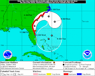
Here is a
report out on the 11:30am conference call with the Virginia Department of
Emergency Management and the National Weather Service and our 1pm Team Norfolk
EOC Briefing.
At the
request of the North Carolina Governor, Virginia Governor McAuliffe declared a
state of emergency as to legally release state assets to assist our neighboring
states. Details available here.
While storm
projections are more reliable and it appears we are not expected to feel the true
wrath of Hurricane Matthew, we will still have some impacts over the
weekend. In fact, the track shifted a
bit northward overnight which will slow the storm’s eastward turn.
Per the hourly
graph, winds and rain are expected this afternoon, but the chance of rain
certainly increases most of Saturday and into Sunday. The
NWS anticipating rainfall accumulation in the range of 3-6” and possibly more
(worst case 8” and some models say less than 1”).
Forecasts
have reflected an increase of winds.
Winds and gusts to pick up Saturday night into and through Sunday. With
the saturated soil, duration of sustained winds in the mid-30’s and gusts at
45+mph, we continue to expect several instances of downed trees, downed lines
and power outages.
Bottom line:
flooding is expected Saturday afternoon / evening as that is when the storm
picks up in intensity.
Tidal
flooding is minor at the moment; however, as influenced by the winds, Sunday’s 3:45pm
high tide is forecasted at 5.1’ (again, with coastal flooding occurring a few
hours on both ends of that 3:45pm peak).
My good friend, Skip Stiles of Wetlands Watch had this to say:
SHORT VERSION = We're getting
high water steadily through next 4-5 days. Starting Sat night at bedtime, move
your cars away from low-lying areas - those areas that flooded yesterday and
Wednesday. If you're in one of those areas, plan to have your streets flooded
constantly Sat and Sun and maybe beyond. We'll get 4" of rain on top of
that!
Looks like a mess later this weekend. High tide Sunday morning - 3 am @ Sewells Point - gets as high as it was yesterday early afternoon. (I saw water on Hampton, Surrey Crescent was impassable as was Llewellyn, etc.). Then the tide never goes down! Low tide Sun @ 10 am is HIGHER than our usual full moon high tide. Next high tide around 4 pm Sun is approaching 3 feet above that level - roads will close, etc. and so on as shown in this chart (click here to go to webpage)
Looks like a mess later this weekend. High tide Sunday morning - 3 am @ Sewells Point - gets as high as it was yesterday early afternoon. (I saw water on Hampton, Surrey Crescent was impassable as was Llewellyn, etc.). Then the tide never goes down! Low tide Sun @ 10 am is HIGHER than our usual full moon high tide. Next high tide around 4 pm Sun is approaching 3 feet above that level - roads will close, etc. and so on as shown in this chart (click here to go to webpage)
Note:
Tropical Storm Warnings end at Duck, NC.
Therefore, Tropical Storm-related alerts will not be disseminated by the
National Weather Service. Instead, alerts
sent will be gale, coastal flooding and wind advisories.
Norfolk EOC
will remain at increased readiness and will maintain a virtual presence. Libraries and Recreation Centers remain open
as scheduled. Norfolk Public Works crews
are operational both Saturday and Sunday maintaining and otherwise tracking
pump stations, storm drains and roads.
Parking safe
havens will be available at the York St. Garage and numerous Norfolk Public
Schools (to be posted at Norfolk.gov).
While current conditions do not warrant emergency sheltering, staff and
facilities are on stand-by should Matthew’s track make an unexpected change.
Important
Messaging is as follows:
- Individuals who experience downed trees can call and report to our Non-Emergency number: (757) 441-5610
- Power outages should be communicated to Dominion Virginia Power at 1-866-DOM-HELP (1-866-366-4357)
- If you see a downed power line, STAY AWAY and report it to Dominion at the aforementioned number.
- If you experience an outage and rely on a mobile generator, be sure to keep it in a well-ventilated space!! (i.e. not indoors, not in garage)
- If you experience an outage, I have attached some great information below on food spoilage.
- DO NOT DRIVE OR PLAY IN FLOOD WATERS!!!!!
- Please
report information using our STORM Mobile tool at http://stormmobile.norfolk.gov/stormmobile/.
Director, Norfolk
EOC
James.redick@norfolk.gov


Wow what a Great Information about World Day its exceptionally pleasant educational post. a debt of gratitude is in order for the post.
ReplyDeleteWater clean up Water restoration