Team,
Hazardous Weather Outlook For Our
Area:
This Hazardous Weather Outlook is
for northeast North Carolina, south central Virginia and
southeast Virginia.
.DAY ONE...Today and Tonight.
Showers and thunderstorms are
expected late tonight. After 3 am, some storms may contain damaging winds and
large hail, with isolated tornadoes also possible.
.DAYS TWO THROUGH
SEVEN...Thursday through Tuesday.
Thunderstorms are expected to
continue through Thursday morning, with some storms potentially becoming strong
to severe. The main threats will be from damaging winds and large hail, with isolated
tornadoes also possible.
Update from Jeff Orrock, Meteorologist
in Charge with the NWS in Wakefield:
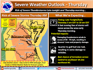
“Attached is the last briefing
for the developing storm system. There have not been many changes today.
Atmospheric conditions till look to support a combination of supercell
thunderstorms ahead of a squall line. Some areas will experience a couple waves
of showers and storms, some this evening and early tonight, but the real severe
potential will be associated with the development of storms from 4 am through
11 am. [In our Norfolk area
specifically, timing currently looks to be sometime between 7am and 9am]
Some areas could experience more
than one round of severe storms during the morning hours on Thursday with some
storms developing ahead of a larger line of storms. The primary threats look to
be damaging wind and tornadoes. If a line of storms develop some larger areas
of widespread wind damage are possible.
While there is still some
uncertainty regarding the exact evolution of the storm system, where exactly
severe weather will strike, and exactly how widespread severe weather will be,
the potential impacts in some areas could be significant.
Please keep up with forecast
updates, potential Tornado Watches and all Warnings via our website, NOAA
Weather Radio, local media and trusted apps. Note that cell phones in areas
where Tornado Warnings are issued should alert via the Wireless Emergency Alert
System.”
Team Norfolk
Again, the hourly graph is provided for your review. As you’ll see, winds pick up tomorrow morning
reaching gusts into the mid to upper 30’s in the afternoon. Folks should be encouraged to secure loose outside
items.
We have a Command and Control conference call discussion scheduled
for 4:30pm; update will be shared soon after.
Emergency Operations Center will be at an elevated level of
readiness with personnel on site overnight.
Community
Messaging:
-
Secure loose
items outside this evening.
Take cover
when a Tornado Warning is received! A Warning means a tornado has been sighted or indicated by
weather radar. Appropriate shelter is the center of a
small interior room on the lowest level (closet, interior hallway) away from
corners, windows, doors, and outside walls. Put as many walls as possible
between you and the outside. Get under a sturdy table if available and use your
arms to protect your head and neck. Have sturdy shoes with you in your shelter space.
Thanks!


