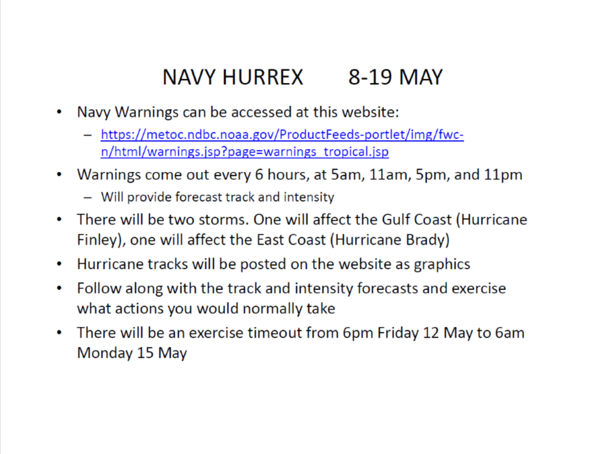
Tuesday, May 9, 2017

Hurricane Exercise 5-9-17 @ 1pm

THIS IS AN EXERCISE…EXERCISE…EXERCISE…

Team,

Brady has strengthened into a Category 1 hurricane and expected to strengthen further still.  The forecast track has not changed nor has the timing by which it’s supposed to be off the coast of SC.
 
Note: when looking at a forecast map and seeing the “cone of uncertainty,” it is very important to understand the eye of the storm is expected to remain within that cone 2/3 of the time.  In other words, it is possible the eye of the storm could fall outside that cone 1/3 of the time!

In this scenario with ~5 days (120 hours) before the arrival of tropical storm-force winds in our area, we would be in Readiness Condition 4 which indicates a tropical weather system has developed which has the potential to impact the locality within 144-96 hours (D-6 to D-4 days).  More than simply reviewing plans, Team Norfolk would conduct an initial briefing, would be testing equipment, taking preparatory actions such as ensuring adequate stock of materials and resources, pre-warning emergency services and personnel, etc. 
Along with talking with the Virginia Department of Emergency Management and the National Weather Service in Wakefield, the Planning Cell would be reviewing the National Hurricane Center’s 2-day and 5-day tropical weather outlook which would be available at 2am, 8am, 2pm and 8pm.  (Note: the 5-Day Outlook shows where a storm might form, not where it’s heading).

If this were a storm with an N/W approach like Isabel in 2003 or our storm of record – the 1933 storm - rather than parallel along the coast, we would be looking at the potential for a larger-scale evacuation.  Fortunately in this scenario evacuation would be likely limited to the coastal areas.  The exact areas would be better determined by the various tools we use called SLOSH (Sea Lake and Overland Surges from Hurricanes) and HURREVAC.  Based on current storm parameters, a SLOSH Maximum Envelope of Water (MEOW) model at this early stage might look something like this:


Note: this sample SLOSH model is errant as it used the current forecast information rather than the advisory for a spot closer to our place on the map which is unavailable at this point of the exercise.

Incidentally, within 48 hours of landfall (once of Watch has been issued) the Storm Surge Unit at the National Hurricane Center will put together a P-SURGE (Probabilistic Storm Surge) which provides greater detail and depths of expected flooding above ground in the impact areas based on the storms strength, speed and direction.

At this early point, we would still likely hold off on requesting a local declaration of emergency until tomorrow’s forecast. We would, however, be sharing important information throughout the community.  More than explaining actions underway, we would emphasize the following:

·        First and foremost, register for Norfolk Alert!  If you fall in an area to be evacuated, this is the tool we’ll use to send the notification.  If you do not have a landline and haven’t registered your cell number, you will not get the message.  Register now by going to Norfolk.gov/emergency or by calling our Norfolk Cares Call Center at 757-664-6510

·        Be sure to have a plan for whether you would evacuate or stay in place.  Have supplies on hand such as non-perishable food items, manual can-opener, enough water and medicines, etc.

·        Be sure to know how to keep informed.  Norfolk.gov, city’s social media sites, NextDoor, TV48, etc.  And for what is likely to be a larger-scale incident, we’ll partner with Norfolk State University’s 91.1FM WNSB to broadcast Norfolk-specific information.

The EOC will continue to monitor and will keep you posted on any updates.

Thank you!

Jim
Director, Norfolk EOC
james.redick@norfolk.gov


THIS IS AN EXERCISE…EXERCISE…EXERCISE…

Monday, May 8, 2017

HURRICANE EXERCISE 5-8-17 @ 1130

THIS IS AN EXERCISE --- EXERCISE --- EXERCISE

Ladies and Gentlemen,
We have received information from Fleet Weather Center on Tropical Storm Brady which is currently located in the Caribbean Sea.  The forecasted track appears similar to that of Hurricane Sandy in 2012 in that it will move Northward through the islands then up the East Coast.  See graphic below (or click here for website).  According to the graph the storm should arrive off the coast of South Carolina Saturday the 13th at 8am.

While it is way too early to determine how TS Brady will be influenced and directed between now and then, the Norfolk Emergency Operations Center will continue to monitor.  There are no conference calls or briefings scheduled at this time; however, if the storm continues to move in the direction forecasted, a discussion will be scheduled.
Thank you and please feel free to contact the EOC with any questions or concerns you may have!

Jim
Director, Norfolk EOC
james.redick@norfolk.gov


THIS IS AN EXERCISE --- EXERCISE --- EXERCISE

Friday, May 5, 2017

Team Norfolk Update 5-5-17 - TORNADO SIREN??

Ladies and Gentlemen,

During this morning’s hazardous weather, I received a few calls about a tornado siren being heard in parts around Norfolk.  Norfolk was not under a Tornado Warning, and if we were, it is important to know the city does not utilize tornado sirens.  Incidentally, to my knowledge, no other locality in Hampton Roads does either.  There are some partner organizations such as Norfolk Naval Shipyard and institutions of higher learning like ODU and William & Mary do utilize them for their campuses.  And certainly as one works their way up the Peninsula there are sirens to be used in the case of an incident at the Surry Nuclear Power Station.  The reason we in Norfolk do not use tornado sirens has to do with cost and effectiveness.

Several years back an analysis was done to determine the effective range of just one siren, and then how many sirens to cover the locality and the total was exurbanite – certainly more than the expected benefit.  The other concern had to do with confusion.  As previously mentioned, in some parts of the region a siren means an incident at a nuclear facility.  In another part a siren was used to kickoff a golf tournament (not joking).  And in such a transient area, people bring their own understanding of what a siren should mean.  Lastly, sirens alone do no reach individuals with hearing challenges.

First and foremost, folks are strongly encouraged to invest in a battery-operated SAME-compatible All-Hazards NOAA radio.  This is the most immediate way to be notified, day or night, of an impending threat.  Also, information and adaptive equipment is available to individuals who happen to be deaf and hard of hearing.
We also use a system developed by Everbridge which we refer to as Norfolk Alert.  This system allows us to send out alert notifications to geographically-targeted areas (i.e. specific neighborhoods) for urgent life-saving information or the subscriber base in general (for updates on a storm response, etc.).  Very important: if we need to send an immediate alert to your community (due to active threat, hazardous materials spill, etc.), it is sent to the landline telephones and those cell numbers which have subscribed into the system.  If you no longer use a landline phone and you have not registered for Norfolk Alert, you would not receive the alert.  So please register now!!!  It's easy, just visit Norfolk.gov/emergency or call the Norfolk Cares Call Center at (757) 664-6510.

Another type of alert you may receive is the Wireless Emergency Alert (WEA).  You have likely received one of these alerts which grabbed your attention with a different ring tone or vibration.  And the message may have been for extreme weather or an AMBER Alert.  These messages, which are designed to reach cell phones within the radius of selected cell towers, can be sent by local and state public safety agencies, FEMA, the FCC, the Department of Homeland Security, and the National Weather Service.  Please click here for more details.

It is our mission to provide timely, accurate, actionable and accessible information throughout an incident.  Therefore, it is critical you understand the means by which an alert may be sent and also take the necessary steps to ensure you receive those notifications!  If you have any questions or concerns, please do not hesitate to contact us in the Emergency Operations Center!
Sincerely,

Jim Redick
Director, Norfolk EOC
james.redick@norfolk.gov

Thursday, May 4, 2017

Team Norfolk Update 5-4-17 - HURRICANE EXERCISE

Team Norfolk,

Next week is National Hurricane Preparedness Week.  As previously mentioned, it is also the Navy’s annual hurricane exercise: HURREX 2017 (info slides attached). As in previous years, we will participate in the exercise play.  Unlike previous years, however, we will send out Alert messages to the Team, conduct conference calls and otherwise post information for the entire community explaining all we would be doing throughout.  In fact, anyone in the community can text the word ‘HURREX2017” to 888777 to receive Team Norfolk updates through Norfolk Alert so please spread the word! 
Note: all exercise messages will labeled as "EXERCISE" and not a real-world incident!

We're looking to find gaps in our plans so they may be addressed prior to June 1, so we're hoping the event and efforts to share information will spark thoughts, ideas, questions and/ concerns throughout our community.  That said, we want people to challenge our plans/actions; devil’s advocates are welcome!!  Otherwise this will not be considered a successful evolution.  Our After Action meeting will take place during our monthly Local Emergency Planning Committee meeting scheduled for Wednesday, May 14 from 1-3pm. 
If you have any questions now or throughout the HURREX, please feel free to shoot us an email or call (757) 441-5600.

Thank you for your time and participation!!

Sincerely,

Jim Redick
Director, Norfolk EOC
james.redick@norfolk.gov


Saturday, April 22, 2017

Team Norfolk - Impending Weather - 4-22-17 @ 4pm


Ladies and Gents,

This is just a quick note about the wet weather and high tides heading our way.

According to the attached hourly graph, rain is anticipated throughout the rest of today (Saturday), tomorrow, Monday and into Tuesday.  The precipitation by itself shouldn’t be too much of a problem; however, combined with higher tides the result will be flooding in the usual spots.  The attached tide chart shows the stacking tides reaching alert levels during the Monday 8:26pm high tide. More to come on this.

I encourage you to visit the NHS Wakefield’s Thunderstorm Briefing page at http://www.weather.gov/akq/Thunder#rain.  Along with the radar, move the cursor over the 24- 36- and 48- hour Precip Forecasts as well as the Day 1 + 2 Precip Forecasts.  Again, the aforementioned Hourly Graph should articulate the amounts of rainfall during which periods.   

The EOC will continue to monitor and keep you posted.  Feel free to contact me with any questions or concerns you have.

Thanks!

Jim
Director, Norfolk EOC
james.redick@norfolk.gov

Friday, April 7, 2017

Thoughts from PBS Independent Lens Film: 'Newtown'

December 14, 2012.  This is a date which changed the lives of an entire community, and especially those who lost something so precious: their child.  Just another day turned into terror when children went to school, but not all came home.  PBS Independent Lens program ‘Newtown’ by filmmaker Kim Snyder told the story of what had occurred and how the community responded.  As with other films focusing on disastrous events, it’s an opportunity for us to not just learn what happened, but steps we can take to improve our plans should a similar incident occur here.  The film is available here until 4/18/17.

The first call to 911 occurred that Friday morning at 9:35am. 
The students and teachers did all they could to survive.  The concept of “Run. Hide. Fight.” was implemented as best as possible in the horrific chaos for those who had an option.  Furthermore, law enforcement and medical response was immediate.

Observations and Lessons - Immediate Response:
With incidents such as this, text messages and social media will be glowing with activity.  At the same time, depending on the venue, 911 centers may be inundated with calls for assistance.  Please note the following

·         Many 911 centers, including Norfolk, do not yet have the ability to receive text messages; this capability should be operational later this year.

·         If you are calling 911 and receive a recorded message, don’t hang up! 

·         If you are vulnerable to the threat, silence your phone!

When law enforcement arrives, do what they say!  Do not expect them to stop to assist you; rather, their sole focus is eliminating the threat – or multiple threats - in order to stop the killing.

If you are a survivor of the incident but are injured, or someone around you is injured, you can make a difference in saving a life.  CPR may be one way.  Also, Norfolk Fire-Rescue offers ‘Stop The Bleed’ training, designed to share simple techniques to stop bleeding from gunshots and other types of wounds learned in the battlefield.  Both CPR and Stop the Bleed training can be scheduled by calling the Norfolk Cares Call Center at 757-664-6510. 
Information.  There was fear and confusion – not just within the school, but outside as well as it appeared parents did not know where to go for information.  Certainly time is needed to truly assess the situation before information can be provided, efforts can be made to support this effort.  Norfolk Police will work with Norfolk Public Schools to account for all the children: those still at the scene and those who may have been able to run away to safety.  Additionally, agencies such as Norfolk Police and Norfolk Fire-Rescue will have Public Information Officers (PIO’s) on scene.  If this incident were a public school, Norfolk Public Schools would have a PIO dispatched as well.  Team Norfolk has additional PIO’s who make up the Joint Information Center (JIC) who can also be assigned to assist with information dissemination.  Every effort will be made to provide those affected, and the entire community, with timely, accurate, actionable and accessible information.  One way to do this for the families is to establish a family reunification center.

As the scene may still be active, or now a crime scene, the Incident Commander will identify an appropriate location for family members to go to receive information on their loved ones.  This is where the NPD and NF-R Public Information Officers will to provide you information, to include whether your child is safe, where your loved one may have been transported for treatment, or worse.  In any case, the plan if for those affected to have someone available at any time who will provide information and answer questions, as well as offer comfort and compassion, the entire time.

Recovery
As was apparent throughout the entire film, grief counseling is crucial.  It was painful to watch one father explain his need to know what his child experienced, what they thought, saw and heard, during the last seconds of their life, “while being murdered, by a gunman, in his first grade classroom.”  Another parent expressed his inability to tell his surviving son “don’t worry, it’s going to be ok,” because his son’s response was “that’s what you said to Ben.”  Grief counseling cannot just be for parents, however.  Nor should it be limited to students and teachers.  It should include everyone involved.  This includes the siblings of the deceased, the school staff and administration – all who knew and otherwise came into contact with the victims on a regular basis, the traditional first responders ( 911, police, fire and medical), as well as those receiving the victims at the hospital(s), those offering emotional and spiritual support, and more.  Response fatigue, survivor’s guilt and critical incident stress are very real threats requiring inclusion in response plans. 

How do you talk with children about what they witnessed or heard?  The gun shots… the screams… the blood… and that people with whom they were close will never come back?  Some of us from a particular generation might turn to the comforting words of Mr. Fred Rogers as he emphasizes the fact our children can talk with us about anything, and that “We will do all we can to keep them safe in any scary time.”  More so, however, professional will be brought on scene to provide the necessary care and otherwise ensure these needs are met.  That said, I don’t suspect one can ever fully get over the loss of a child, sibling or parent.

Next Steps
There is much that goes into keeping the children in our community safe.  This includes taking steps to ensure controlled access to school facilities, documentation of potential warning signs, and the planning, training and exercises which occur on a regular basis between Norfolk Public Schools (and many other institutions), public safety agencies and many more Team Norfolk partner organizations.  Every parent has a role as well: get to know your school’s plan.  Furthermore, since an active threat can occur anywhere, know how you would respond.  Complete Free FEMA Training: IS-907: Active Shooter: What You Can Do at https://training.fema.gov/is/courseoverview.aspx?code=IS-907 , get familiar with the Run. Hide. Fight. video developed by ReadyHouston and practice it at work, school and your place of worship.  Lastly, remember taking steps to increase awareness and preparedness now will help minimize chaos, confusion and fear during an actual incident.

I want to thank Ms. Snyder for making this important film and the parents to whom my heart goes out; I’m committed to learning the lessons from their grief.  They have unknowingly made an impactful difference in our community’s plans.
Sincerely,

Jim
Director, Norfolk EOC
james.redick@norfolk.gov

Thursday, April 6, 2017

Team Norfolk Post-Storm Update 4-6-17 @ 1:40pm

All,

Please note the Tornado WARNING expired as of 1pm and the Tornado WATCH extended to 4pm.

The WARNING was based on radar not observations; there is no evidence or reports of actual tornado touchdowns.  The only storm-related calls into the 911 center involves flooding at the 7900 block of Shore Dr, Oklahoma Ave and Shirley Ave.  Power outages are minimal with only 13 out of 97,053 Dominion customers impacted as of 1:20pm.

If anyone in the community experienced damages, they are encouraged to document the impacts and contact their insurance company.  The Norfolk Cares Call Center is available to receive any reports and otherwise answer questions at 664-6510.  For emergencies, call 911!

For city staff, please report any damage to Lori Crouch.

Team Norfolk partner agencies, please report any damages to the Norfolk EOC so we may provide a comprehensive report to the Virginia EOC.

Again, while the Tornado Warning has been cleared, the Tornado Watch is still active which means conditions exist for tornado activity: vigilance is key.

The latest hourly graph is provided below for your review.  Wind gusts in the upper 30mph range can be expected into the evening, and then gusts in the lower to mid 30's throughout the night and into tomorrow (Friday).  Chance of rain drops significantly at 2pm and temperatures cool overnight with a low of 48 by 6am in the morning.  Certainly more pleasant conditions than received around 1pm!

Please contact us with any questions or concerns you may have.

Thank you!

Jim
Director, Norfolk EOC
james.redick@norfolk.gov