Friday, March 17, 2017

Team Norfolk Update 3-17-17 @ 3pm - RESPONSE REQUESTED


Team Norfolk Local Emergency Planning Committee Meeting Minutes
Huge thanks again to John Roberts and Jeff Orrock for their presentations on amateur radio and tools/resources available through the National Weather Service!  Minutes and materials from the meeting are available online at http://www.norfolk.gov/Archive.aspx?AMID=119.

Upcoming Events…

Advanced SKYWARN
Team Norfolk partnership between Old Dominion University and Norfolk EOC offering this course Monday (3/20/17) at 6pm at ODU.  Details available at http://www.weather.gov/akq/skywarn.

FBI / City of Norfolk Active Threat Preparedness Event
The FBI will be hosting a community outreach event (free and open to the public) dealing with critical incidents on Saturday, April 8th, from 9 a.m. – 12 p.m. at the Norfolk Fire Training Center located at 7120 Granby Street. The mission is to establish confidence in each agencies’ skills and ability to command and control dangerous situations while educating the public on how to respond.  Registration and details available at https://www.eventbrite.com/e/active-shooter-preparedness-event-tickets-32660957804.

Team Norfolk Local Emergency Planning Committee Meeting
Scheduled for Wednesday April 19 from 1-3pm at the Norfolk Department of Public Health, the group will meet to discuss and gain awareness of various volunteer organizations who contribute significantly to response efforts.  Some traditional and some not as well known.


EXTENDED POWER OUTAGE EXERCISE – RESPONSE REQUESTED        
On Tuesday, May 2 from 9am-12:30pm, the Norfolk Emergency Operations Center will be participating in a tabletop exercise coordinated by the Virginia Department of Emergency Management (VDEM).  Without going into the details of the scenario, the outage is human-caused, widespread, and long in duration (~ 1 month).  Request for information: the exercise begins 3 days after the outage began with no signs of restoration.  As such, what are your concerns?  What resources might you be looking for?  Think about whether your facility has a generator, what it powers within your facility, fuel capacity and plans for replenishment.  Likewise, what are your information needs during such an incident?  How would you expect to receive this information?  Please send me your plans and/or thoughts at your earliest convenience so we may incorporate them into exercise play and our overarching Team Norfolk materials.  If you are interested in participating in the event, please let me know that as well! 

Naval Station Norfolk HURREX 2017
As mentioned during Wednesday’s LEPC meeting, Naval Station Norfolk will also be conducting their annual Hurricane Exercise (HURREX 2017) May 8-19.  The Navy has been gracious in allowing us here at the Norfolk EOC to play along with this exercise as well.  If your organization is interested in exercising your hurricane plans with us, please let me know and we’ll respond and otherwise communicate as if we were experiencing the incident together.  For accreditation needs / proof of exercise, I’m happy to distribute a certificate of participation to those who play.  And as we do with all exercises, we’ll conduct an After Action Report.

Thanks and have a great weekend!

Jim
Director, Norfolk EOC
james.redick@norfolk.gov

Monday, March 13, 2017

Team Norfolk Update - Impending Weather 3-13-17

Team,

Norfolk is under a Winter Wind Advisory until 10am tomorrow (Tuesday).  Additionally, the Governor has declared a State of Emergency for the Commonwealth for the impending winter storm throughout parts of Virginia.
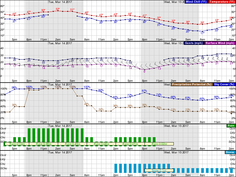
While parts of the State may expect upward of 15" of accumulation, this should be a non-event for Norfolk.  Based on the hourly graph below, we are expected to receive rainfall possibly this afternoon and very likely overnight through the morning hours.  Rainfall amount of ~1” is expected over this 12+ hour period.  Temps overnight are in the low 50’s and sustained winds in the mid-teens w/ gusts in the low to mid 20’s.

Tuesday afternoon brings a 36% chance of snowfall.  Again, per the NWS Probabilistic Snowfall Forecast, the most likely scenario accumulation should be less than 1”; worst case is in fact 1”. 
There is no activation of the Emergency Operations Center nor recommended changes to operations.

The early morning hours of Wednesday will bring colder temperatures, with a low in the upper 20’s and wind chill in the teens.  To protect our residents experiencing homelessness, a Warming Overflow Warning (WOW) coordination call will be scheduled to discuss anticipated conditions for the week.
Lastly, if you plan to attend Wednesday’s Team Norfolk Local Emergency Planning Committee (LEPC) meeting, please RSVP with Karen Lovely at karen.lovely@norfolk.gov.  Topics will include a presentation on Severe Weather from the National Weather Service, a presentation on Amateur Radio by John Roberts and a discussion on the hurricane evacuation zone update.

Thanks!
Jim
Director, Norfolk EOC
james.redick@norfolk.gov   

Friday, March 10, 2017

Team Norfolk Update - Weekend Weather - 3-10-17 @ 3pm

Team,

Based on a 2pm conference call with the State Emergency Operations Center and the National Weather Service (NWS), the weather weekend should be uneventful.  As reported yesterday, temperatures drop and the potential for snowfall exists Sunday morning.  Accumulation probabilities are less than 1”.  Nonetheless, Norfolk Public Works are at the ready with teams on standby for the weekend.

Thanks to the amazing folks of Norfolk NEST, Human Services, NPD, CSB and Office to End Homelessness, all is set for Warming Overflow Warning (WOW) activation to ensure overnight accommodations for our residents experiencing homelessness.

The NWS reported another system expected to occur early next week causing rain Monday night into Tuesday.  Temperatures are well above freezing during this time; however, there is a chance of snowfall Tuesday evening.  This forecast is definitely subject to change with it being 72 hours out. 

Coastal flooding does not appear to be a threat with either weather system.

We’ll keep you posted on any updates.  In the meantime, feel free to monitor the NWS Probabilistic Snowfall Forecast tool and the Briefing Page.

Thanks, have a great weekend, and GO SPARTANS TONIGHT IN THE MEAC SEMIFINALS!

Jim
Director, Norfolk EOC
james.redick@norfolk.gov

Thursday, March 9, 2017

Team Norfolk - Weekend Weather 3-9-17 @ 3:50pm

Ladies and Gentlemen,

The Norfolk Emergency Operations Center (EOC) is monitoring the weather expected this weekend.  Per the hourly graph attached below, the timing of any snow suggests the morning hours of Sunday.  As for the amount, at this time, the National Weather Service's Probabilistic Snowfall Forecast shows the potential for 4”, but the likelihood of less than 1” (also provided below).  The Virginia Department of Emergency Management has scheduled a Winter Weather Conference Call tomorrow afternoon after which I will share with you any updates.
Snow or not, temperatures dip below freezing Friday night/Saturday morning with wind chills in the 20’s.  This occurs again Saturday and Sunday nights as well.  Therefore, a Warming Overflow Warning (WOW) for our residents experiencing homelessness is in effect for the weekend.  Likewise, messaging throughout the community should be to bundle up!  Infographics provided below.

Again, we’ll continue to monitor and keep you abreast of forecast changes.  In the meantime, please feel free to contact us with any questions or concerns you may have.
Separately, our monthly Team Norfolk Local Emergency Planning Committee (LEPC) scheduled for 1-3pm Wednesday the 15th will have Jeff Orrock, Meteorologist-In-Charge with the NWS in Wakefield who will be presenting on severe weather and John Roberts to discuss the critical need and capabilities of amateur radio.  Please RSVP with karen.lovely@norfolk.gov if you plan to attend.

Thanks, and GO SPARTANS AND MONARCHS!
Jim
Director, Norfolk EOC
james.redick@norfolk.gov


Tuesday, February 7, 2017

Team Norfolk - Potential Thursday Snow 2-7-17 @ 5:30pm

Ladies and Gentlemen,

The following comes from Jeff Orrock, Meteorologist in Charge at the NWS in Wakefield:

“A strong storm system will approach the region Wednesday and cross the area Thursday. This will result in gusty winds and scattered snow showers. While current forecasts call for no little to no accumulation, due to the strength of the system and forecast uncertainty snow accumulations are possible. There is the potential that an inch or more of snow could accumulate over portions of the Northern Neck and Eastern Shore. Confidence in any possible snow accumulation is low, but we want folks to be aware. Scattered snow showers are expected late Thursday into Thursday evening, the question is how long will snow last in any one location and how much accumulation could result.

Windy conditions are expected everywhere with gusts of 30 to 40 mph close to the Bay and coast. Some gusts to 45 mph are possible along the immediate coast. Winds increase Thursday morning, but the highest winds are expected late Thursday into Thursday night.”

Norfolk should not be directly impacted by this event; however, the hourly graph is attached for your review reflecting midnight Wednesday through Friday at midnight.  As you’ll see, rainfall is likely throughout the morning hours Thursday and then 30% chance of a light snowfall in the afternoon. Likelihood is minimal accumulation; reasonable worst case is still under 1”.  In fact, Norfolk has a 42% chance of experiencing 0.1”.  While sustained winds and gusts pick up to around 20mph and 32mph respectively Thursday morning, temperatures drop dramatically in the evening from 51° to 32° (and wind chills into the upper teens) late Thursday night.  Temps pick up again throughout the day Friday.

Again, this should be a non-event for Norfolk.  No watches, warnings, activations.  For those associated with our "WOW" efforts, Scott Mahone will schedule a coordination call.

Thanks!

Jim
Director, Norfolk EOC


Thursday, January 26, 2017

Patriots Day Movie - Lessons Learned 1-26-17

I recently had the opportunity to see the movie, Patriots Day which tells the story of April 15, 2013 Boston bombing, the investigation and pursuit of those who perpetrated the attack.  From the perspective of a casual viewer, it was an excellent film depicting the dedicated professionals who protect the homeland and resilience of a community during a painful and confusing time.  Of course, I’m not a casual observer…  My infliction as an emergency manager has me jotting down notes in every book I read or movie I see which could serve to improve our community’s emergency operations plans.  Obviously books and movies are not my primary means for planning material; there are numerous reports, studies, templates, guides and so forth we utilize.  Books and movies, however, add to the effort and otherwise assist in preventing a ‘failure of imagination’ as referenced in the 9/11 Commission Report.  (While the reference is made regarding intelligence efforts, it is equally applicable to anticipating any curve balls associated with any disaster response).   

There were several observations made of the movie associated with incident response, unified command, resource needs, public information, family assistance centers, grief counseling, etc.  However, if you’re time and interest permits you to see it, I challenge you to ask yourself “What if?”  What if YOU were near that finish line where the explosions occurred?  Are you equipped to help in a meaningful way?  Do you know CPR?  Did you know Norfolk Fire-Rescue offers a free and timely program called “Stop the Bleed” ? 
The film depicts very realistic aspects of a disaster.  This includes the likelihood of cell phone outages.  Significant events have a way of overwhelming cell towers due to calls for help or to loved ones.  If you experience a cell phone outage, try sending a text instead.  Additionally, while cell phones may be unable to connect, the older landline phones typically can for those who still have them.

Speaking of landlines, it is important to know how you might be alerted during such emergencies. If a similar incident to the Boston bombing occurred here, in partnership with the Norfolk Police Department and the Unified Command, the Emergency Operations Center could send out a Norfolk Alert to your home or device with information, description of the suspect(s) and instructions (i.e. shelter in place, call hotline to report information, etc…).  In order to ensure you get this message, it is imperative you register to receive the alerts at Norfolk.gov/Emergency (bottom of page) or by calling the Norfolk Call Center at 757-664-6510.   Again, Norfolk Alerts regarding life safety will be sent to landlines and Norfolk Alert subscribers.  If you do not have a landline, and you haven’t registered your cell number, you will not receive this alert.
Depending on the incident there is another way you could be notified: the Wireless Emergency Alert (WEA).  In the past you may have received an unusual ring tone or vibration on your device alerting you of impending hazardous weather or an AMBER alert.  Incidentally, you may also recall mention of a “smartphone terror alert” in New York last year.  This was Wireless Emergency Alert, designed to help local, state and federal agencies reach cell phones within a particular radius around selected cell towers.  Click here for a WEA Public Service Announcement.  Again, the criteria by which WEA messages will be sent is much more stringent than Norfolk Alerts.

Lastly, in the same vein of a community coming together, I encourage you to get involved.  Whether it’s through our Community Emergency Response Team (CERT), Public Health’s Medical Reserve Corps (MRC), or any of our partners like Amateur Radio, the American Red Cross Coastal Virginia, Civil Air Patrol, Foodbank of Southeastern Virginia, Norfolk Emergency Shelter Team (NEST), Operation Blessing, Operation Brother’s Keeper and many, many more.  If you have the interest, we’ll connect you with the right organization.  Just please keep in mind, the right time is NOW to get affiliated and trained before the next incident occurs.   
Thanks and enjoy the movie!

Jim
Director, Norfolk EOC
james.redick@norfolk.gov

Wednesday, January 11, 2017

Team Norfolk: FINAL WINTER STORM UPDATE 1/11 @ 5pm

Ladies and Gentlemen,

The following comes from Bill Sammler, Warning Coordination Meteorologist with the National Weather Service in Wakefield:

After a 2 day period of much warmer temperatures, a cold front will move through the region from the north during the day Friday, as Arctic high pressure builds southward into the region. This will usher in colder temperatures Friday afternoon through Saturday. Meanwhile, moisture from the Midwest will begin moving over top of the cold air near the ground, generating some light precipitation spreading west to east from late Friday evening into Saturday, especially along and north of a Fluvanna county to Chincoteague line. There will be enough cold air near the ground for some of the precipitation to fall as sleet and possibly freezing rain.

At this time, the precipitation, regardless of form, is expected to be light, with any travel impacts expected to be minor. Temperatures will be warming again from late Saturday into Sunday, so any precipitation beyond Saturday evening will be in the form of liquid rain. We will be refining the forecast over the next couple days, and will provide you another update sometime Thursday afternoon.

This looks to be a non-event for Norfolk.  Nonetheless the hourly graph depicting Friday 12pm to Sunday 12pm is provided below as well as the 72-hour rainfall forecast graphic.

This is the final update related to the recent winter weather. 
I want to take this time to thank all who worked this even, who braved long hours in hazardous conditions – away from family - to get our community back to where it needed.  I want to thank those who volunteered to assist others in need.  Those who were committed to helping, caring for and treating our residents experiencing homelessness with compassion, dignity and respect as was the case through the fantastic efforts of NEST (overnight sheltering) and the Community Services Board (daytime warming station).  Much thanks to those who armed themselves with a shovel, a kind heart and linked up with Operation Blessing in our Snow Buddies program!  Their efforts helped people like one 8-month pregnant military spouse whose husband was deployed, a woman recovering from breast cancer surgery only a week ago, another challenged with Parkinson’s and diabetes, and so many more.  And thanks goes to so many who responded by keeping the community informed.  Our Norfolk Cares Call Center (757-664-6510) performed superbly as always! Our friends in the media did an incredible job explaining the complexities of these incidents as well as provide real-time situation awareness.  So many in the Twittersphere and other social media sites did wonderfully communicating crucial information and various needs.  And so many knew, understood and explained incidents like these just take a little time.

In other words, it was amazing to see the community come together and respond to an infrequent incident which impacts our daily routines.  To me, this is resilience.  And it’s something on which to build, a springboard to get more involved.  Jesse Scaccia wrote a great piece in The Virginian-Pilot entitled “10 resolutions for being a better Norfolk citizen in 2017.”  Emergency Management has ways in which to get involved!  One way to get to know your neighbors and to volunteer is to participate in our free Community Emergency Response Team (CERT) training!!  This program is for people of all ages and abilities to get the tools and know-how to ensure your own neighborhood is informed and prepared for the next natural or man-made incident!  Also get involved with our Local Emergency Planning Committee (LEPC), where you don’t just get familiar with current threats, you get familiar with (and contribute toward) our plans!  To learn more about how you can get involved in these and other efforts, or recommend / request ideas and information, please contact us!  As I’ve said before, if we can leverage the talents, resources and expertise within our community from the individual to the largest organization (i.e. this is Team Norfolk), our city will be ready to respond and recover from anything which comes our way.

Thank you Team Norfolk!

Sincerely,

Jim
Director, Norfolk EOC
james.redick@norfolk.gov