Friday, January 6, 2017

Team Norfolk Update 1-6-17 @ 9am - WINTER STORM WARNING

Team,

Here is the morning brief from the National Weather Service in Wakefield:
Confidence continues to increase for a significant winter storm across south-central and southeast VA into northeast NC on Saturday. Expected snow amounts remain on the order of 6-10" with locally higher amounts to 12" across southeast VA, all of Hampton Roads into northeast NC, and much of the Eastern Shore. Snow arrives across southern areas late this evening and continues through Saturday morning before ending from west to east Saturday afternoon into Saturday evening. The biggest questions that still remain are just how much snow falls NW of Richmond where there could be a sharp cutoff between 2-4" of snow and little to none, and how much sleet mixes with snow across coastal northeast NC which could hold down snow amounts a little from the current forecast. Due to winds gusting up to 35 mph and heavy snow Saturday morning, there is the possibility of near-blizzard conditions along the coast, especially in Virginia Beach and Currituck County, NC.

Whatever snow does fall will be slow to leave as temperatures Saturday, Sunday and even into Monday will be hard pressed to reach 32 degrees. Lows will be in the single digits to low 20s.
8-12" expected for Norfolk.

Norfolk is under a Winter Storm Warning.

I am also attaching the Hourly Graph for your review.

More to come after 11:30am Team Norfolk Conference Call.

Thanks!
Jim
Director, Norfolk EOC
james.redick@norfolk.gov


Thursday, January 5, 2017

Team Norfolk Update 1/5/17 @ 5pm WINTER WEATHER UPDATE

Forecast:

A WINTER STORM WATCH is now in effect for Norfolk.
A Snow Warning is expected early Friday morning.

From Jeff Orrock with the National Weather Service in Wakefield: See the attached briefing with all the latest details. Snow amounts have been increased across all of Central VA as well as MD. Snow amounts have also been increased across portions of the Tidewater and Hampton Roads. 

 Winds have also been increased some and the combination of wet snow and gusty winds could result in some power outages in areas which receive the heaviest snow falls. Snowfall rates in some areas will approach 2 inches per hour at times. 

[Note: based on NWS’ Snow Probabilistic Forecast, there is the potential for 1’ of snow, with 8” likely]

 Timing of the snow Saturday remains unchanged with snow spreading in from the south after midnight and the heaviest snow from 5 am through 2 pm. 

This has the potential to be a crippling snow event across potions of the Tidewater and Hampton Roads in regards to travel. The combination of cold temperatures and heavy wet snow would result in dangerous travel Saturday and even into Sunday. 

Realize exact snow forecasts will likely change with later forecast updates. 

 
Team Norfolk Winter Weather Plan
Available here: http://www.norfolk.gov/DocumentCenter/View/28284
 
Highlighted Preparatory Actions:
Team Norfolk has a solid, yet ever improving plan.  Roles, responsibilities and expectations are understood and coordination calls have been underway.  Here are some highlights:

EOC Activation
The Norfolk Emergency Operations Center has been activated on a virtual basis.  There will be an ongoing yet limited presence in the Emergency Operations Center with a regular schedule for updates and conference calls.  Coordination and communication continues with Team Norfolk partners, to include Norfolk Police, Norfolk Fire-Rescue, Norfolk Public Schools, higher education institutions, U.S. Navy and more.

 A State declaration is anticipated as well as a local emergency for the simple reason of requesting and dispatching resources.
 
Last Team Norfolk Coordination Call was today at 3pm, and the call with the NWS and Virginia Department of Emergency Management was at 4pm.  Next Team Norfolk Coordination Call is scheduled for Friday at 11:30am.

 
Life Safety
A plan is in place for our vulnerable residents experiencing homelessness.  Our NEST program – inclusive of Houses of Worship who generously agree to provide overnight accommodations during the winter months, do a fantastic job!  For those times when need exceeds capacity, and the environmental conditions threaten life and limb, we were able to establish a strategy to provide support to NEST in an effort to keep all residents out of the elements.  That is in place for this weekend.  Additionally, in the event municipal operations are impacted and the usual daytime refuge locations are unavailable (libraries, recreation centers, etc.), a plan is in place to accommodate this need.  This is a tremendous effort among NEST, Norfolk Human Services, Community Services Board, Office to End Homelessness, Norfolk Police Department, Libraries, Operation Blessing and the American Red Cross!

Roadways, Infrastructure and Facilities:

Norfolk Public Works
Efforts well underway preparing vehicles and equipment.  24-hour operations begin tomorrow and will remain until the incident is over.  With the rain finished Friday morning, DPW operations will begin pre-treating the roads and bridges. 

Recreation, Parks and Open Spaces (RPOS)
With the expectation of downed trees and limbs due to those impacted from Hurricane Matthew, RPOS tree crews are on alert.  Moreover, they are prepared to address those areas of responsibility per the Team Norfolk plan.

Parking Garages
To accommodate off-road parking to better allow pre-treatment and snow clearing, General Services will make available a few parking garages.  Exactly which garages and the times will be posted at Norfolk.gov.

Norfolk IMPACT Call Center
The IMPACT Call Center (757-664-6510) will be available to receive calls both Satguirsday and Sunday between the hours of 10am-5pm.

Closures and Cancellations
Status of City-related services and events for the weekend will be determined around noon Friday.

Resource Needs:
  • Request has been made to the State Emergency Operations Center for additional capacity to clear/plow snow.
  • New blankets, sweatshirts, sweatpants and coats for our homeless residents.
  • Need salt and volunteers to assist Snow Buddies program.  Details are as follows and attached below...
Volunteer Needed:  Sunday  & Monday (January 8th & 9th)

Orientation Times:  8:30 AM & 1:00 PM Each Day

Operation Blessing will provide snow shovels, tools and work order coordination.  We just ask that volunteers provide their own transportation to and from the job sites each day.  For all day and morning volunteers, we will provide lunch free of charge on site.  Please wear snow boots/hard sole shoes and weather appropriate clothing.  Operation Blessing will give each volunteer an Operation Blessing T-shirt.

Where:  Meet at the Operation Blessing Mobile Command Center which will setup on the CBN Campus at: 977 Centerville Turnpike Virginia Beach, VA

In the parking lot of The Coporprate Support Building (The Building Facing Centerville Turnpike with the Satellites on the side.)

Serving:  Norfolk, Virginia Beach and Chesapeake (We will expand out as we have volunteers.)
Thank you!!

Jim
Director, Norfolk EOC
james.Redick@norfolk.gov


Team Norfolk Update 1-5-17 @ 10am WINTER WEATHER

All,

Forecast:
From our friends at the National Weather Service in Wakefield:

Not much has changed with respect to the light wintry precipitation event for tonight and early Friday morning. Snow accumulations were reduced to a half inch or less for areas in and around Richmond over to the northern Neck. Snow amounts of 1-2" are still possible across the lower MD Eastern Shore, especially along and north of a Cambridge to Salisbury to Ocean City line. All rain is expected across Tidewater VA/Hampton Roads into northeast NC.

For the second event, late Friday night into Saturday, confidence continues to increase for significant snowfall across south-central and southeast VA into northeast NC. Snow amounts were increased this morning across the VA Tidewater, all of Hampton Roads, and into northeast NC to 4-8" with locally higher amounts possible. The question that still remains is just how far north (inland) the snow reaches given the considerably dry air that will be in place across northern/central VA limiting snowfall potential. A Winter Storm Watch will likely be issued by this afternoon. Whatever snow does fall will be slow to leave as temperatures Saturday, Sunday and even into Monday will be hard pressed to reach 32 degrees. Lows will be in the teens to low 20s.
 
Watches / Warnings
None at the time.

Team Norfolk Winter Weather Plan
Available here: http://www.norfolk.gov/DocumentCenter/View/28284

Additional Considerations
Expecting a heavier, wet snow which can expose many tree limbs weakened during Hurricane Matthew.  Also, this type of snow is more difficult (and takes longer) to plow.

Dangerous travel Saturday with cold temperatures. Lows drop into the lower 20s Saturday and Sunday night and highs Sunday and Monday struggling to get above freezing. 

Highlighted Preparatory Actions:
  • Pre-treatment of major roads to occur throughout Friday
  • Ensuring adequate accommodations for residents experiencing homelessness.
  • Prepare for deployment of post-snowfall Snow Buddies program.
  • IMPACT Call Center (664-6510) to be open 10-5 Saturday and Sunday
Closures
No closures at this time.

Resource Needs:
Please contact us at the Emergency Operations Center with any resource needs.

Battle Rhythm / Coordination Activities:
Team Norfolk Section Chiefs / DCM’s Call at 9am
NEST Coordination Call at 1pm
VDEM/NWS Conference Call at 2:30pm.
Team Norfolk Conference Call at 3pm

Important Messaging:

Protect your pipes from freezing

Check on your neighbor, particularly those who are a little more vulnerable to winter conditions

Keep pet indoors during extreme cold temps

Looking for volunteers now who might be willing to assist with our Snow Buddies program – to assist those who need a helping hand shoveling out from the snow to make their medical appointments, etc…  Please leave name and contact info at 757-441-5584.
 
Thank you!
 
Jim
Director, Norfolk EOC
james.redick@norfolk.gov


Wednesday, January 4, 2017

Team Norfolk: WINTER WEATHER 1-3-17 @ 3:30pm

Team Norfolk,

The following weather brief comes from Jeff Orrock, Meteorologist in Charge for NWS Wakefield:

Attached is our latest thinking regarding the light snow Friday morning, mainly north of I-64 and across MD, and the more significant winter storm likely Saturday. 

There is still quite a bit of uncertainty regarding the Saturday snow forecast. It is not clear exactly how much snow will fall and how far inland the heavier snow will extend. There will be a sharp cut off in snow amounts somewhere across the western Tidewater and south Central VA. Should the storm track closer to the coast, higher snow totals would edge closer to Richmond. 

What we are fairly sure of:

Increasing confidence in significant snow across southeast VA and northeast NC

For Norfolk… Saturday forecast shows 3 to 4 inches in Norfolk, but could go to 4 to 6 inches. Expect forecast amounts to change some in time. 

Snow will accumulate quickly Saturday morning. 

Temperatures will be very cold with lows in the teens and highs at or below freezing from Saturday through Monday. 

More in the way of preparatory actions and messaging to come in the morning!

 Jim
Director, Norfolk EOC


Thursday, December 15, 2016

Team Norfolk Update 12/15/16 @ 3:30pm COLD WEATHER


Team Norfolk:

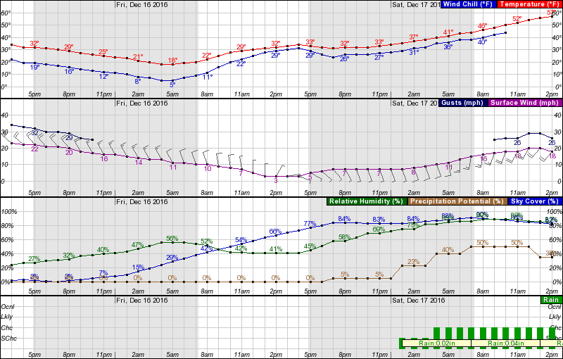
Provided below is a brief from Bill Sammler, Warning Coordination Meteorologist with the National Weather Service in Wakefield.  Hourly forecast graph information attached for your review.  Bottom line: very cold temperatures tonight through Saturday morning; precipitation does not appear to be a threat for our area.

Messaging should include dressing appropriately (infographic below), taking steps now to prevent frozen pipes, keep your pet indoors and check on those who may be a little more vulnerable to the conditions.

Thanks and be safe!

Jim
Director, Norfolk EOC
james.redick@norfolk.gov

“The coldest airmass this winter continues moving into the region this afternoon. Temperatures will fall quickly through this evening, with most areas being in the 20-25 degree range by 9 pm. Winds will continue to be strong and gusty this evening, especially near the Bay, Ocean and Sound, making it feel 10-15 degrees colder than the actual air temperature. A very cold night is in store across the region tonight, with low temperatures below 20 degrees throughout our region. Most locations on the Lower MD Eastern Shore, and inland from the Bay/Sound in VA/NE NC in the 10-15 range. Wind chills around or just below zero on the DELMARVA and Northern Neck, and in the single digits elsewhere, will make Friday morning bitterly cold. A wind chill advisory, for wind chills zero to -5 degrees is being issued for our DELMARVA and Northern Neck counties, except for Northampton county VA. Friday's max temps will struggle to reach 32 degrees everywhere. Wind chills will not be much of a factor by mid-morning Friday, except across our DELMARVA area, and coastal Hampton Roads/NE NC, where winds continue to be gusty, but deceasing, through noon.

Potential for Wintry Precipitation (mainly interior VA)

There is little change to our thinking from yesterday regarding the potential for light freezing rain late Friday night through mid-morning Saturday. Low pressure organizing in the southern Plains Friday evening will intensify as it moves toward the Great Lakes region on Saturday. As warmer air surges toward the region from the southwest, a light wintry mix of snow, sleet and freezing rain will be possible Friday night into Saturday morning, especially west of Interstate 95, and north of a Richmond VA to Ocean City, MD line. The most likely areas for light accumulations of ice will be along and west of a Vienna MD to Tappahannock VA to Richmond VA to Emporia VA line. The emphasis here is light accumulations (generally less than one-tenth of an inch). However, since temperatures will have been so cold for 36 hours or so prior to the onset of precipitation, any freezing rain could cause rapid development of hazardous traveling conditions in the area mentioned above during the period from midnight Friday night through mid to late morning Saturday. The last areas for precipitation to turn to rain will be Fluvanna and Louisa counties. Even in these areas, only light ice accumulations area expected. All precipitation with the weekend event beyond noon Saturday will be liquid rain, with temperatures well above 32 degrees.

Additional info will be provided tomorrow afternoon. However no briefing packages are anticipated, due to the light and short-lived nature of the event. The front page of our briefing web page will have the latest storm total snow/ice graphics on the right side of the page. An afternoon update to these graphics will be available by 5 pm.”


Thursday, December 8, 2016

Team Norfolk Update 12/8/16 - FEMA Assistance / Winter Weather Plan & Mtg.

Hurricane Matthew Update:

As of close of business yesterday, December 7, Norfolk has had 565 individuals and businesses registered for FEMA assistance.  Housing Assistance has totaled $373,873.99 and “Other Needs” have totaled $81,035.63 for a total of $454,909.62 in FEMA Individual Housing Programs assistance ($7,621,621.63 among all 7 declared localities).  As a reminder, Individuals & Household Program (IHP) provides money and services to people in presidentially-declared disaster areas; Housing Assistance (HA) provides assistance for disaster-related housing needs; Other Needs Assistance (ON) provides assistance for other disaster-related needs such as furnishings, transportation and medical expenses.
We are unaware of any unmet needs; however, if you or anyone you know experienced damage from Hurricane Matthew and have not yet registered with FEMA, there is a deadline to do so of January 3, 2017.  In other words, if in doubt as to whether you may qualify for assistance, call now!  There is absolutely no obligation.


December Team Norfolk Local Emergency Planning Committee (LEPC) Meeting:
This month’s meeting is scheduled for Wednesday the 21st from 1-3pm at the Norfolk Health Department and the focus is on Winter Weather.  Science Officer Mike Dutter from the National Weather Service in Wakefield will be joining us to speak about the upcoming season as well as some new snow probability forecasts and wind products.  Moreover, we will discuss in detail Team Norfolk’s Winter Weather DRAFT Plan.  Please review the document at http://www.norfolk.gov/DocumentCenter/View/27910 and be prepared to offer feedback (either by email or during the meeting).  After our collective review, the document will be finalized and posted for the community.

Remembering the holiday season is not always a time of cheer for all in our community, as you feel led, we will receive during our meeting any canned goods or new or gently used toy or other item you’re willing to bring.  We are committed to delivery all donations to the appropriate organization like the Office to End Homelessness, the Food Bank or other who provide direct assistance to those most in need.
Thank you, Team Norfolk!

Sincerely,

Jim
Director, Norfolk EOC
james.redick@norfolk.gov

Wednesday, November 30, 2016

Team Norfolk Update 11-30-16 @ 5:15pm

Team,

I trust all is well with you and yours during this holiday season!  Please see the latest updates below…
Hurricane Matthew Update
Since the last Hurricane Matthew update, FEMA reported 422 individuals in Norfolk have registered / received assistance – second to Virginia Beach among the four localities originally included in the FEMA Individual Assistance declaration.  Because the number of people in Norfolk visiting the Disaster Recovery Center (DRC) at the Workforce Development Center had remained in the single digits for well over a week, and FEMA typically looks to close down DRC operations when such numbers are in the single digits, Norfolk’s DRC had closed operations this past Saturday.  Nonetheless, assistance is still available to anybody who wishes to register
online at http://www.DisasterAssistance.gov or by calling 1-800-621-FEMA(3362) or 1-800-462-7585 (TTY) for the hearing and speech impaired.  The toll-free telephone numbers are still operating from 7:00 a.m. to 9:00 p.m. (local time) seven days a week until further notice.  Downloading the FEMA app is another way to access DisasterAssistance.gov for federal disaster assistance.

Southside Long-Term Recovery Group
A Southside Long-Term Recovery Group is being established and will meet tomorrow (Thursday) where Southeastern Virginia VOAD (Voluntary Organizations Active in Disaster) member organizations, faith-based organizations, private nonprofits, civic groups and private sector business are forming to support the ongoing recovery needs of Southside Hampton Roads.  This group will meet to collaborate and coordinate with local governments in order to fully support the repair/rebuilding efforts of survivors homes.  If you and your organization are interested in participating, please let me know!
On the Public Assistance / Government Infrastructure side, a workshop facilitated by the Virginia Department of Emergency Management was conducted this afternoon.  After the City submits its Request for Public Assistance (RPA) form, FEMA will schedule a kickoff meeting.  The City’s Risk Manager is the lead contact for submitting all City information to the State.  Likewise, he will be coordinating with FEMA on their visit and also conducting Just-in-Time training on documentation needs with the appropriate agencies.  For those who want to take a deeper dive into the Public Assistance process, please review the FEMA Public Assistance Program and Policy Guide.  Herein lies all the answers!

Hazard Mitigation Funding
Today’s workshop also relayed information about post-incident Hazard Mitigation Grant Program (HMGP) availability, which means there are various projects for which Norfolk (and other localities) can apply.  It is important to maintain realistic expectations however.  The amount of HMGP funding is based on percentage of total eligible Individual Assistance and Public Assistance under the declaration.  The guestimate which will be available through HMGP from Hurricane Matthew is approximately $3M.  Therefore large-scale projects are unlikely.
Recovery Plans
One focus throughout this recovery process, and discussed during the November Local Emergency Planning Committee (LEPC) meeting, is Team Norfolk’s Recovery Plan(s).  Please visit our Plan Review Portal at http://www.norfolk.gov/index.aspx?NID=3422&ART=5363&ADMIN=1.  WE NEED YOUR HELP!!  Please review the DRAFT Short-Term - Intermediate Recovery Strategy and provide us any feedback.  To be clear, along with the Basic Plan Concept of Operations, there are Hazard-Specific Annexes (all soon to be posted as well) which contain material pertinent to the individual nuances for those incidents such as Active Shooter, Winter Storms, Tropical Storms, etc.  This Short-Term – Intermediate Recovery Framework is focused on that phase beyond initial response operations and up through months after any disaster.  Focus is on meeting the immediate needs of the community.  Team Norfolk’s Long-Term Plan is also under development which will address recovery issues for months and years afterward.  This Long-Term plan will be inclusive of Norfolk’s Resilience Strategy, plaNorfolk 2030, Vision 2100 and Hazard Mitigation Plan (2016 update near completion).  In other words, while rebuilding and rebounding from a catastrophic incident, Team Norfolk will not be starting from scratch; rather, we will be doing so in a purposeful and methodical way following a path toward resilience laid down ahead of time with constant community input.


Conclusion
Hurricane Matthew is not over!  While not as flashy as immediate response operations, the recovery component – inclusive of the FEMA reimbursement process – is critical and those folks working to make it happen should be commended.  It requires painstaking attention to detail which can either result in FEMA reimbursement or no reimbursement.  Likewise, this incident, along with that which occurred on the campus of The Ohio State University, and the upcoming winter season, are constant reminders to not only review our plans but update them as well – TOGETHER.  That is our commitment and we’re thankful for all who take the time to help!
Sincerely,

Jim
Director, Norfolk EOC
james.redick@norfolk.gov