Tuesday, October 4, 2016

Hurricane Matthew Update 10-4-16 @ 4:30pm

Team,

Here is an update from Jeff Orrock, Meteorologist-in-Charge with the National Weather Service in Wakefield:

“Please see the attached updated summary. There have not been many changes other than the updated afternoon track from NHC and forecast rainfall. 

Again, do not get too wrapped up in minor track changes from one Advisory to another. The exact track and timing of the storm remain uncertain, however, minor shifts in track will NOT decrease the threats of wind and flooding possible later this weekend. There is still a lot of time before the storm moves this far north this weekend and changes in the forecast can be expected. 

Use our local NWS forecast page http://www.weather.gov/akq/ to access local forecasts. Go to the Hourly Weather Graphs to ascertain our best estimate as to the timing of the winds and rain realizing these forecasts will change in time as the forecast track changes. 

For mobile devices you can obtain local forecasts at http://www.nws.noaa.gov/widgets/

Jeff’s briefing materials are attached below and indicate upward of 7” of rain for Norfolk.  Moderate to Major flooding expected over the weekend.  Also, as mentioned before, the flooding + additional rainfall on top of the already-saturated soil = downed trees and widespread power outages.

Lastly, I am providing the gist of a message sent to City staff moments ago.

Thank you!

 Jim


Ladies and Gentlemen,

This is a brief update on Hurricane Matthew.  The key issues are as follows:

  • Rainfall will precede the storm starting late Friday and lasting through Saturday into Sunday.  Expecting 4-8” (on top of our already saturated ground).
  • Wind gusts increase significantly Saturday morning, then hurricane force gusts that afternoon.
  • Storm winds with soft and saturated ground soil will result in downed trees, and thus downed power lines = widespread power outages.
  • Storm tides over the weekend are anticipated to rival Irene (2011) or Isabel (2003).
The bottom line is Hurricane Matthew will be a significant impactful event. The good news is there is ample lead time to take preparatory action.

Here are some actions we encourage everyone to do now:

  • Take steps before the incident to prepare self/family/loved ones, vehicle(s) and home/business (information available at Norfolk.gov/Emergency).  Also check on neighbors, particularly those with access or functional needs.
  • Make copies of important paperwork (insurance, birth certificates, etc.)
  • Begin to secure all loose yard items which could become projectiles in heavy winds.
Along with the updates we’ll send throughout the incident, please remain informed by maintaining communications with your Supervisor, visiting Norfolk.gov, viewing TV48, checking Norfolk’s social media and registering for Norfolk Alert! 

Thank you and please feel free to contact us with any questions you may have!


Hurricane Matthew Update 10-4-16 at 2pm

Ladies and Gentlemen,

I want to thank the City Manager's Pastoral Round Table for taking the time to listen to my hurricane briefing, to pray for our efforts and otherwise consider ways in which they may help strengthen our community's resilience through Norfolk Operation Brother's Keeper!
 
Here is the latest from Jeff Orrock, Meteorologist in Charge with the National Weather Service in Wakefield. 
 
Thanks!  Jim

“There is increasing confidence that Matthew will impact our region bringing threats of heavy rain/flooding, high winds and storm surge/coastal flooding. The extent of the threats and damage will depend on the storm track and intensity. While we are still several days out from the storm impacts, starting late Friday and lasting into early Sunday, given the forecast intensity and track preparations will likely need to begin Wednesday. 

 Realize the storm track and forecast impacts may still change. We encourage everyone to NOT get caught up in minor changes in forecast track changes from one Advisory to another over the next 24 to 36 hours. Rather let's focus on forecast trends in the longer term and prepare for what could be a very significant event. We can adjust as forecasts change in time.”


Hurricane Matthew Update - READINESS LEVEL 3 - 10-4-16 @ 11:45am

All,

We are now at Readiness Condition 3 which means a forecasted arrival of tropical storm-force winds with 96-48 hours.
Ladies and gentlemen, we must prepare for a significant impact.  A conference call with the Virginia Department of Emergency Management (VDEM) and the National Weather Service (NWS) enclosed a shift further to the west (toward the east coast) with the possibility of the storm speeding up by 6 hours, arriving Friday night.
Winds expected to begin Friday night with gusts increasing to 30-35mph.  Gusts up to 45mph anticipated by daybreak Saturday and hurricane force gusts Saturday afternoon.
The ground is already saturated; expect downed trees and downed power lines.
A reprieve from the winds is not expected until Sunday afternoon.
Rainfall with precede the storm arriving Friday evening and occurring all day/night Saturday and into Sunday morning.  4-8” rainfall expected and could be higher if track continues to move westward.
High tides Saturday and Sunday to be problematic.  While it’s too early to forecast exact level, there is the potential they be similar to Irene (2011) and Isabel (2003).
Again, this will be a high impact incident. 
More to follow.
Thanks!
Jim
 

Hurricane Matthew Update 10-4-16 @ 10am

Team Norfolk,

The following information was provided by Mike Dutter of the National Weather Service in Wakefield:

“Good Morning - Attached is the a briefing for Hurricane Matthew. Based on the latest track, there is an increasing chance for moderate to significant impacts from Matthew across SE VA, NE NC and the MD eastern shore late Friday into the Weekend. A few things to note:
  • Due to the already very saturated ground, heavy rains (4-8 inches) from Matthew could cause moderate to significant flooding
  • Coastal Flooding and Storm Surge are highly dependent on the track and intensity, but moderate to significant coastal flooding is possible based on the latest track forecast, especially in Hampton Roads and NE NC.
  • Saturated ground will allow for trees to become more susceptible from being downed, even from 40 mph winds. 
Moreover, I have attached the Virginia Department of Emergency Management (VDEM) updated dashboard as provide by Bruce Sterling, Region 5 Coordinator.

Similar to the Virginia Emergency Operations Center (VEOC), the Norfolk EOC continues monitoring for future developments and City crews have begun taking protective actions.  A conference call with VDEM and the NWS is scheduled for later this morning; a summary update will be posted later today.
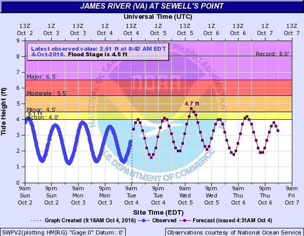
Incidentally, prior to the storm’s anticipated arrival on Saturday, we’re looking at tidal flooding at the 4.7' mark (4.5' is minor flood stage) TOMORROW (Wednesday) at the 12:28pm high tide (and about an hour before and after…).

Please take this time to report any actions or communicate anticipated resource requests.
Thanks!

Jim
Director, Norfolk EOC


Monday, October 3, 2016

Hurricane Matthew NWS Update 10-3-16 @ 3:18pm

Team,

Please see the below comments from
Mike Dutter of the NWS in Wakefield.  Thanks!  Jim

“Good afternoon - Attached is a briefing slide regarding Hurricane Matthew. In short, there is growing confidence of a significant hurricane off of the southeast U.S. coastline late this week. However, there is much less confidence on the track beyond mid-week, and what affects, if any, will occur over the region this weekend. Please note, even if we are not directly impacted by Matthew, any heavy rainfall on the periphery of the storm could cause some flooding due to our already saturated ground in many areas. In addition, due to the wet ground, trees may be more susceptible to being downed even from moderate winds. 

For the latest information, please visit http://www.weather.gov/akq/Matthew

Hurricane Matthew Update 10-3-16 at 1pm

Team,

The Virginia Department of Emergency Management’s 11:30am updated dashboard is attached for your review.  Likewise, I’ve attached a graphic of Matthew’s latest track update.   According to the National Hurricane Center’s forecast discussion: “ While Matthew is expected to be a little weaker once it moves into the Bahamas as the shear increases somewhat and the ocean heat content decreases a little, it is expected to remain a dangerous hurricane through the next 5 days…In addition, it is still too soon to determine whether, or how Matthew could affect the remainder of the U.S. east coast.”  It is important to remember the average NHC track errors at days 4 and 5 are on the order of 180 and 240 miles, respectively.

With so much time and uncertainty with the forecast, actions taken by the City include (in addition to those mentioned in previous update) the following:
  • Maintaining communications and situational awareness with the Virginia Department of Emergency Management (VDEM) and the National Weather Service.
  • Increased Readiness Condition to Condition 4 (meaning a tropical weather system has developed which has the potential to impact the locality within 144-96 hours).
  • Preparing the Emergency Operations Center for activation
  • Department of Public Works (DPW) are servicing and preparing their trucks and equipment.
  • DPW also preparing to clear storm drains in problem areas.
  • Norfolk EOC to Reach out to Faith Community / Operation Brother's Keeper.
Dr. Jeff Stern, VDEM Director, is briefing the Governor this afternoon.  An initial Norfolk Emergency Operations Center briefing is scheduled for Wednesday at 1pm and will be conducted via Conference Bridge and Adobe Connect.  We cannot accommodate everybody on the call so invitations will be forthcoming.  If you do not receive one, a summary of the call will be shared with everyone.

Lastly, please encourage everyone in your social circles to subscribe for Norfolk Alert by visiting Norfolk.gov or calling our IMPACT Care Center at (757) 664-6510.  Norfolk Alert is one means by which we can keep the community informed – along with Norfolk.gov, the City’s social media sites as well as channel 48.  If we can’t contact them, we can’t alert them!

Thank you!!


Hurricane Matthew Update 10-3-16; Norfolk EOC at Readiness Condition 4

Team,

The morning GFS model shows Hurricane Matthew over OBX and Hampton Roads with rain and winds this Saturday.  Still many variables exist; however, we are increasing the Norfolk EOC Readiness Condition to Condition 4, which means a tropical weather system has developed which has the potential to impact the locality within 144-96 hours (D-6 to D-4 days).  With this change in Readiness Condition comes some important steps for all of Team Norfolk to take:
·         Review and implement department playbooks and checklists;

·         Establish communications among Emergency Support Function (ESF) partners;

·         Prepare to document / track any storm-related costs;

·         Begin preparatory actions by identifying stocks of materials, pre-warning emergency services, personnel, etc.;

·         Identify resources which may need to be moved/secured for protection;

·         Identify resource needs and availability

Norfolk EOC to prepare for a full activation, beginning with an initial briefing to occur over the next day or so.  This may occur electronically.
Norfolk EOC will also confirm with Norfolk Public Schools the availability of primary shelter locations.

Remember, the NWS has created a site specific to Hurricane Matthew, available at http://www.weather.gov/akq/Matthew.

There are no conference calls with the Virginia Department of Emergency Management or the National Weather Service at this time.  VDEM’s latest dashboard from earlier this morning is attached.  Next update expected around 11am.
Thanks!

Jim
Director, Norfolk EOC