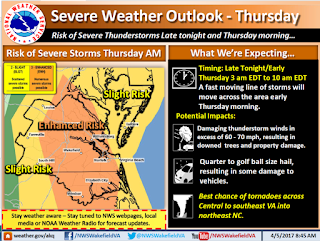
Hazardous
Weather Outlook from the National Weather Service:
“Showers and thunderstorms are expected late tonight. After 3 am,
some storms may contain damaging winds and large hail, with isolated tornadoes
also possible.
.DAYS TWO THROUGH SEVEN...Thursday through Tuesday.
Thunderstorms are expected to continue through Thursday morning, with
some storms potentially becoming strong to severe. The main threats will be
from damaging winds and large hail, with isolated tornadoes also possible.”
The
following is provided by Mike Montefusco, Senior Meteorologist with the
National Weather Service in Wakefield:
“Attached,
please find the latest briefing information regarding severe weather potential
tonight into Thursday morning. Overall, we're expecting an initial batch of
showers and thunderstorms moving across the Coastal Carolinas this evening,
potentially pushing across SE VA/NE NC this evening before midnight. This
initial area of showers should be predominately sub-severe. After a brief lull
in the early overnight hours, a second round of showers and thunderstorms are
expected after 2am EDT tonight, with a significant severe weather threat for
our area between 3 am and 10 am EDT. Please note that the tornado threat has
been expanded to include Central VA and the Metro Richmond area for Thursday
morning. The next briefing will be sent by 3 pm this afternoon. Please be sure to monitor weather.gov/Wakefield for the latest
information.”
I am attaching the hourly graph for your review and will provide more following the NWS 3pm update.
Thanks!
Jim
Director, Norfolk EOC
james.redick@norfolk.gov
Director, Norfolk EOC
james.redick@norfolk.gov


No comments:
Post a Comment