Norfolk is under a Winter
Wind Advisory until 10am tomorrow (Tuesday). Additionally, the Governor has declared a
State of Emergency for the Commonwealth for the impending winter storm throughout
parts of Virginia.
While parts of the State may expect upward of 15" of accumulation,
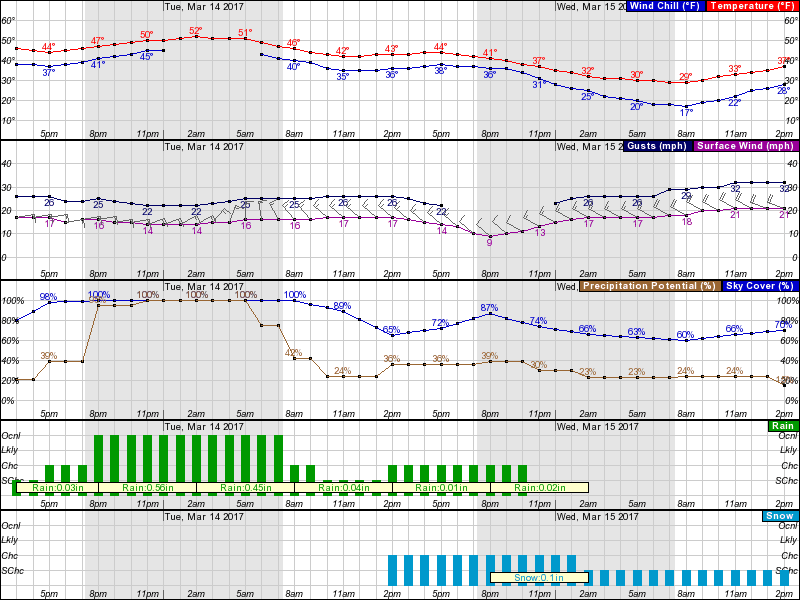
this should be a non-event for Norfolk. Based on the hourly graph below, we are
expected to receive rainfall possibly this afternoon and very likely overnight
through the morning hours. Rainfall
amount of ~1” is expected over this 12+ hour period. Temps overnight are in the low 50’s and
sustained winds in the mid-teens w/ gusts in the low to mid 20’s.
Tuesday afternoon brings a 36% chance of snowfall. Again, per the NWS Probabilistic Snowfall Forecast,
the most likely scenario accumulation should be less than 1”; worst case is in
fact 1”.
There is no activation of the Emergency Operations Center nor
recommended changes to operations.
The early morning hours of Wednesday will bring colder
temperatures, with a low in the upper 20’s and wind chill in the teens. To protect our residents experiencing homelessness,
a Warming Overflow Warning (WOW) coordination
call will be scheduled to discuss anticipated conditions for the week.
Lastly, if you plan to attend Wednesday’s Team Norfolk Local
Emergency Planning Committee (LEPC) meeting, please RSVP with Karen Lovely at karen.lovely@norfolk.gov. Topics will include a presentation on Severe
Weather from the National Weather Service, a presentation on Amateur Radio by
John Roberts and a discussion on the hurricane evacuation zone update.
Thanks!
JimDirector, Norfolk EOC
james.redick@norfolk.gov
No comments:
Post a Comment