Ladies
and Gentlemen,
The
following is a summary of today’s heat advisory and Team Norfolk’s response
efforts. Thanks to all for your prompt responses and assistance!! If
there are any questions, or other activities for which I am unaware, please
email me at your earliest convenience.
Thank
you!
Jim
Director, Norfolk EOC
Hazardous Weather Outlook: Hot and humid conditions are expected
Wednesday and Thursday. Heat index values around 105 degrees are expected each
afternoon. Per the attached chart, heat index values this high will pose a risk
of heat related illnesses, if precautions are not taken. Heat advisories may be
needed for portions of the area, especially Thursday.
Status: Norfolk
Public Libraries are available for a reprieve from the heat during normal
operating hours. Mike Wasserberg reports Office to End Homelessness
activated their water outreach for this week. Street outreach has hit most of
the known hotspots including parks, libraries and the beach areas. Staff
reports low numbers of people experiencing homelessness in the outdoor areas
where they would be exposed to the high temps. Also coordinating with
NCSB PATH and Road to Home outreach staff. Mike
also reports the Salvation Army opened its 19th Street Hope Center
as a community cooling location until 4pm.
Many, many thanks to Ms. Joleen Jones, Manager at
Walmart on Military Highway, as well as Mr. Anthony Butts of Lowes on Military
Highway, for their incredibly generous donations of bottled water for the outreach efforts to our
most vulnerable populations!! Arrangements underway for the pickup and
distribution of said water. Thanks also to Jody and Operation Blessing
who are standing by to provide more upon request!
Messaging /
Information Resources:
These are the message points approved by Norfolk Public Health. Thanks,
Dwayne and Eve!!
-
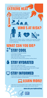
Dress appropriately for the heat.
Wear light-colored, loose fitting clothing that permits the evaporation of
perspiration.
- Prepare for, and be aware of signs
of, heat stress / heat illness.
- Protect pets by bringing them
indoors.
- Do NOT leave children or pets in an
un-air-conditioned vehicle.
- Anyone without access to
air-conditioning can seek temporary relief during business hours at
city multi-service centers or libraries. Contact the Norfolk Cares
Call Center at (757) 664-6510 to ask for the nearest open city facility.
- Increase water consumption!!
- Conduct outdoor work or exercise in
the early morning or evening when it is cooler. Outdoor workers should drink
plenty of water and electrolyte-replacement beverages and take frequent breaks
in the shade or in an air-conditioned facility. Those unaccustomed to working
or exercising in a hot environment need to start slowly and gradually increase
heat exposure over several weeks.
- Check on our seniors. Take the
initiative to visit seniors to look for signs of heat related illnesses. It
takes the elderly nearly twice the time of younger people to return to core
body temperature after exposure to extreme temperatures.
We also received the following from
Dominion Energy regarding energy
summer saving tips:
- Raise your thermostat to 78º. If you are away
from home for more than eight hours, raise the thermostat setting and you can
save for each degree of setback. This will reduce the amount of energy used to
cool your home while you're away. You can learn more about your thermostat
online by visiting the U.S. Department of Energy website.
- Keep shades closed when the air conditioner
is on. Sunny windows can add heat to your home and can make your air
conditioner work two to three times harder.
- Check and clean filters. Cleaning and
replacing air conditioning filters monthly allows the system to run more
efficiently.
- Clear attic vents. If the home has an attic
fan, make sure it is functioning properly.
- Install ceiling fans and make sure they are
blowing down. Don't underestimate the importance of ceiling fans. Moving air
over the body provides a cooling effect. Most fans have a switch to change the
fan direction. Make sure ceiling fans are blowing downward (in a
counter-clockwise direction) to send air past your body. Turn fans off when the
room is unoccupied.
- Postpone activities that require hot water
and large energy use – such as washing dishes or clothes – to early morning or
late evening. This will keep from adding more heat and humidity to the
home. Use the dishwasher and clothes washer late in the evening. When
used during the day, these appliances produce additional heat, causing your air
conditioner to work harder.
- Use cold water to wash dishes and clothes.
This will save on water heating costs.
- Unplug equipment not in use. Electric
chargers, televisions and audio/video equipment use electricity and produce
heat even when they are not in use. Running an older refrigerator can use up to
three times the energy of a modern one. Unplug any appliance when it's not in
use.
Heat Index chart and Infographics attached:


